Follow
the podcast on

It’s official - El Nino has begun.
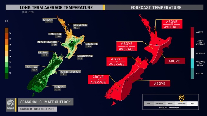
The National Institute of Water and Atmospheric Research (Niwa) announced the start of the weather cycle in its Season Climate Outlook for October to December today.
It increases the likelihood of “dramatic” temperature swings in these months, the outlook says, bringing periods of unseasonably warm weather followed by sharp, cool southerly winds.
There’s a higher chance rainfall will be lower than normal for many regions around the country, meaning drought conditions and a greater risk of fires than last year.
Wind will be more powerful, with the outlook warning there could be periods of potentially damaging winds.
Niwa said the weather pattern was likely to continue over the summer.
Fire and Emergency NZ’s national wildfire manager Tim Mitchell said fire season “is going to be different. We’re going to see a see-sawing of fire risk”.
“Now is the time to really prepare for the coming condition, clearing vegetation around structures, managing water supplies and forming a plan,” Mitchell said.
‘On track to be up there with some of the strongest El Ninos’
Niwa meteorologist Ben Noll said: “El Nino is finally here. We’ve been talking about it for a long time.”
Projections show it could be one of “the stronger El Nino events in the last couple of decades. And that means some pretty big impacts,” he said.
- NZ set for a scorcher of a summer
- Spring storm: Record heat for east, rain, wind alerts for south, then snow
“[There will be a] temperature rollercoster. It could be 30C one day and then 15C the next. That’s typical for spring, but El Nino is going to elevate and enhance that level of variability,” he said.
The eastern sides of both islands were likely to see above-average temperatures and the west and south of the South Island will get above-average rainfall.
As Niwa’s principal scientist Chris Brandolino spoke of the low rainfall rates projected for some areas he was so taken aback by forecasts he exclaimed “holy smokes!”
Throughout October, rainfall rates were likely to be at or below normal for most of the country, with the North Island and top of the South in line for the most dramatic anomaly.
Moving into November, “we have to watch out”, Noll said.
/cloudfront-ap-southeast-2.images.arcpublishing.com/nzme/PCUMD77LKZFWRPCDOJH46UN36E.png)
The National Institute of Water and Atmospheric Research announced the start of the El Niño weather cycle in its Season Climate Outlook for October to December today.
“We had that big flooding event in September - so inland Otago, around Queenstown Lakes, parts of Southland, the West Coast, Fiordland - there could be some very strong and impressive fronts that track through that region in the coming months,” he said.
Brandolino said those fronts would “lose their oomph” as they moved north over the North Island: “That’s why the dryness risk is there.”
However, there would be higher rainfall rates in other places, Noll said.
The west of the South Island could see higher than normal rainfall.
Wind strength will be greater than normal across most of the country because the difference between air pressures near New Zealand, the pressure gradient, will be higher than normal.
“This will come with periods of potentially damaging winds,” Niwa’s outlook read.
Noll said El Niño would “bring some really windy conditions”.
More westerly winds from this pressure pattern will contribute to “prolonged dry spells” about the east and north of both islands.
The risk of marine heatwaves, “like those that have occurred in recent years”, however, is low, Niwa said.
Regional marine heatwaves could develop around the north and east of both islands, though.
Noll and Brandolino pointed to sea surface temperature anomalies - “the engine room behind atmospheric patterns”, Noll said - where there was “a lot going on”.
Measurements taken in a key region where El Nino is monitored in the equatorial Pacific Ocean in September showed temperatures had passed the threshold for a “strong” El Niño.
“We’ve been watching the development of El Nino and what we’ve seen over the last month,” Noll said, “is that that key monitoring region in the central part of the Pacific known as Nino 3.4 has actually jumped over the threshold for a strong El Nino”.
“[The threshold is] 1.5C and we’re actually at 1.6C above average in that area.
“And that puts us on track, this year, to be right up there with some of the strongest El Ninos,” Noll said.
/cloudfront-ap-southeast-2.images.arcpublishing.com/nzme/HT7THEOBD5F4FNG5F5LL7R5PHQ.png)
El Niño increases the likelihood of “dramatic” temperature swings in these months, the outlook says, bringing periods of unseasonably warm weather followed by sharp, cool southerly winds.
Brandolino said the high measurement readings were significant given they were from September - “this early in the El Nino arc”, he said.
“Once we reach 2C above average,” Noll said, “we tend to ascribe that as ‘very strong’. That means big impacts.”
Another climate pattern, the Indian Ocean Dipole, which leads to extremely dry conditions in Australia, will also be in play.
“This pattern looks very similar to what happened in 2019 - and although 2019 didn’t have a fully-fledged El Nino, do you remember what happened?”
The Indian Ocean Dipole threw parts of New Zealand’s North Island into a severe meteorological drought.
“This is a reason to be concerned,” Brandolino said, “now we have at least a strong El Nino in conjunction with [the Indian Ocean Dipole].”
30C by next Friday, Niwa forecasts
Air pressure anomaly patterns showed the next 10 days would bring wind gusts over 100km/h this weekend, threatening power cuts and tree damage.
“This is not your run-of-the-mill, typical wind event we’ve got coming in on Saturday,” Noll said.
“Things change quickly and dramatically,” he said, “with a big high [pressure system] building north of the North Island.”
Both Brandolino and Noll said parts of the country could be above 30C next week.
“That’s early,” Noll said, “Last year we didn’t hit 30C until November. It’s certainly ahead of schedule.”
Bradolino said the early heat was “a nice example” of what New Zealand could see over the next two to three months.
Fire and Emergency’s Mitchell said the wildfire risk was slightly above normal along the east coasts of both islands - where rainfall was likely to be lower too - and slightly below normal where rainfall rates were projected to be higher than usual at the bottom and west of the South.
“This year is going to be different. We really need you to keep up to date with wildfire risk conditions and think about those activities that could cause sparks or ignitions.”
Raphael Franks is an Auckland-based reporter who covers breaking news. He joined the Herald as a Te Rito cadet in 2022.
Take your Radio, Podcasts and Music with you


