LISTEN ABOVE FOR THE LATEST ON THE WEATHER WITH NEWSTALKZB
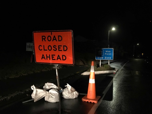
Another road block has been set up on Wellington's south coast as the worst of the weather is set to hit the region.
Waves have begun overtopping the sea walls and encroaching on land south of the city.
Ōwhiro Bay resident Eugene Doyle said Wellington City Council has put a new cordon up at the intersection of Ōwhiro Bay Parade and Happy Valley Road.
He said the south side of the bay, leading to Red Rocks, is closed to traffic other than residents' vehicles.
The overtopping of the waves onto the road has already started, Doyle said.
"Fairly shortly we may not actually be able to get out if the overtopping gets too serious."
Wellington City Council Civil Defence Controller Derek Baxter said at this stage they were not intending to undertake precautionary evacuations at Ōwhiro Bay.
"But unfortunately we do have a large number of sightseers and people who have decided to come out and look at the power of the ocean along the south coast and we definitely don't want to have them heading along that piece of road."
Baxter said he could see ten cars at the Ōwhiro Bay cordon which shouldn't be there.
"It has become the exciting thing of the evening to pull up into one of the bays and shine your headlights and see if you can use them like a flash to get a great photo and that is not helping us or emergency services."
Wellington Mayor Andy Foster earlier declared a local state of emergency as the region was expected to face up to eight-metre-high swells.
Waves as high as 1.5 metres could hit houses on the south coast, Foster told Newstalk ZB's Heather du Plessis-Allan.
Wellington Mayor Andy Foster earlier declared a local state of emergency as the region was expected to face up to eight-metre-high swells.
Waves as high as 1.5 metres could hit houses on the south coast, Foster told Newstalk ZB's Heather du Plessis-Allan.
The Antarctic blast has descended on much of the country, bringing bitterly cold temperatures, heavy rain, hail and even snow as far up the country as the Bay of Plenty.
Foster said the sea was "pretty wild" this morning with the swell at about 5.5 metres.
But his main concern was at 9pm when waves will reach their strongest.
The declaration means evacuations for properties in Breaker Bay. The bay is expected to take the brunt of the Southerly swell and storm expected at high tide tonight.
Properties to be evacuated on Breaker Bay Rd are between numbers 53 and 194.
There will be roadblocks at the northern and southern entrances to Breaker Bay after 6pm to prevent people entering the area.
/cloudfront-ap-southeast-2.images.arcpublishing.com/nzme/AHKDL2S7OPZ4M42ORFWZIDUZ5Q.jpg) Angry seas batter the Wellington coastline as a cold southerly flow from Antarctica bashes up the country. Photo / Supplied / Lilia Alexander
Angry seas batter the Wellington coastline as a cold southerly flow from Antarctica bashes up the country. Photo / Supplied / Lilia Alexander
Foster said advice from forecasters over the past few hours indicated southerly swells of six metres or more could present a significant risk to life and property if they overtop areas alongside the South Coast, similar to storm events in April 2020 and in 2013.
Residents need to be evacuated from Breaker Bay before the situation turned dangerous for residents and emergency services, Foster said.
Newstalk ZB reporter Jack Crossland is at the summit above Breaker Bay.
By 8pm, he said the weather had turned "extreme".
"When I hopped out of the car before, you could barely stand on two feet."
Crossland said around the corner in Tarakena Bay the waves were "absolutely massive".
He said you can barely hear yourself, and all you can see is the white of the breaking waves.
Authorities have asked evacuees to see if they can stay with family and friends outside the evacuation zones in the first instance. However, if people are stuck, they can contact Wellington City Council on 04 499 4444.
Interislander ferry sailings have been cancelled tomorrow.
From Thursday, the backlog of passengers and freight will be cleared as soon as possible.
Additional sailings will be scheduled this coming weekend to help get through the backlog, with services expected to be back to normal by Sunday.
Antarctic blast hits South Island
/cloudfront-ap-southeast-2.images.arcpublishing.com/nzme/4CM7SFT443IPR3QVKYBHYUN35Y.jpg) The Crown Range Road from above. Photo / George Heard
The Crown Range Road from above. Photo / George Heard
A number of roads across the country are closed following heavy snowfall this morning, including Desert Rd and State Highway 2 near Gisborne. Drivers are urged to travel with "extreme caution" due to ice and to delay travel where possible.
A strong wind watch is in place for much of the South Island, including Dunedin, Christchurch and North Otago.
New Zealanders are advised to wrap up warm and check road closures following a dumping of snow.
Flights have been cancelled across Invercargill, Queenstown, Christchurch and Wellington.
Many coastal bus routes and ferries in the capital are also cancelled as a heavy swell warning remains until 11pm from Baring Head to Sinclair Head.
Wind chill means single-digit temperatures across much of the country will feel even colder, Metservice warns.
Large waves already lashing Greater Wellington's coastline are expected to be at their heaviest at high tide around 9.18pm tonight.
Exposed coastlines are likely to see overtopping waves causing damage to property, deposition of debris, driftwood, sand and gravel, making access difficult or dangerous and possible road closures, Metservice warns.
An Antarctic blast has descended on much of the country, bringing bitterly cold temperatures, heavy rain, hail and even snow in the Bay of Plenty.
Snow flurries are falling in Mamaku and power is out to hundreds of customers in the Mamaku and Hamurana area.
Mamaku School principal Garry Veysi said there was a snow flurry on the school grounds at around 11.30am.
Excited students were released from class to play in the snow, he said.
Snow flurries have also graced elevated parts of Wellington, with sleety showers lower down.
Twelve Air New Zealand flights in the South Island have been cancelled today and 25 at Wellington Airport alone. Most remaining flights at the capital airport are running to schedule with minor delays, mostly to flight arrivals.
/cloudfront-ap-southeast-2.images.arcpublishing.com/nzme/6YNGNBVA2ML6UARIPBHD6RM2AA.jpg)
Air New Zealand aircraft covered in snow this morning. Photo / Air New Zealand
Snow has closed State Highway 2 between Gisborne and Wairoa. No detour is available and drivers are urged to delay travel.
Road snowfall warnings are in place for Napier-Taupo Rd, Desert Rd and Remutaka Hill Rd. A heavy snow watch is in place for Taihape, the Tararua Range, Canterbury and Marlborough.
Meanwhile, wind is toppling trees in Auckland.
John O'Leary said wind and hail downed a tree in Ararimu this afternoon, pushing it into a powerline and leaving locals with cold showers and a blocked road.
The country's coastline is at risk of enormous and dangerous swells, possible flooding and erosion, MetService said.
The greatest impact is likely to be on Wellington, with a very present threat to property.
Large waves are expected in the inner harbour area, Petone and Eastbourne, but the south coast is set to be hit the hardest.
Snow in the capital has already reached sea level this afternoon, but is expected to affect Remutaka Hill, State Highway 2, through to this evening. The road currently remains open with contractors working around the clock to clear ice.
Up to 8cm of snow may settle near the summit of State Highway 2.
People heading home tonight should keep an eye on public transport updates, with a number of ferries, buses and flights being cancelled or delayed.
Temperatures are mostly in the mid-single digits for much of New Zealand but it will feel much colder due to the wind-chill effect, MetService said.
/cloudfront-ap-southeast-2.images.arcpublishing.com/nzme/SP22VKAZRUWUXZ7RKE3IUJW6H4.jpg)
A tree blown over by strong winds on Ararimu Rd, south of Auckland. Photo / John O'Leary
Wellington, for example, was 6.5C at midday, but winds of 93km/h made it feel closer to 1 degree.
Wellingtonians are being urged to prepare for possible evacuations and to leave their home at short notice.
Civil defence reiterated a warning to stay out of the water after two kayakers feared missing in Wellington harbour were found 22km away after a search was mounted in mountainous seas off Wellington's south coast.
An extensive hunt on sea, land and air was earlier launched for the two men who had been seen in trouble off Wellington's coast at Seatoun.
The pair were found safe in Petone.
The southerly swell is expected to reach 8m on Tuesday evening, with the highest risk period coinciding with high tide at 8.24am and 8.54pm.
By Wednesday night the swell is likely to ease to around 4m.
MetService meteorologist Angus Hines warned today's waves could be damaging to low-lying properties and roads. People in the area are urged to stay out of the water and be prepared to leave their properties if they are at risk.
The Wellington Region Emergency Management Office said the impact of today's morning high tide could be similar to what was experienced in Ōwhiro Bay in April last year when 6m waves battered roads and flooded properties.
The agency said people who lived in homes that had been impacted by past swells and storm events should be prepared for these potential impacts again.
Take your Radio, Podcasts and Music with you


