- Widespread surface flooding has hit the Wellington region and motorists have been asked to avoid non-essential travel and work from home if they can.
- Trains on the Kāpiti Line have been replaced by buses between Plimmerton and Paekākāriki due to a landslide.
- Multiple roads are closed due to flooding in the Hutt, and Kāpiti residents are being warned to take care
- MetService is expecting another 40mm of rain to fall across the region in the next six hours - the main concern being around high tide this afternoon.
A Hutt Valley man claims raw sewerage is flowing on a well-used walking track as heavy rains put pressure on the wastewater system.
The Wellington region has been under a deluge today, with rivers and streams flooding, roads closing, and slips causing problems around the lower North Island.
This afternoon on Facebook user posted a video showing water flowing from underneath a manhole on Bushey Way track in Lower Hutt’s Maungaraki.
“Yes that is toilet paper, raw sewage flowing into our awa,” he wrote. Pieces of water appear to be toilet paper can be seen streaming down the hill.
A Wellington Water spokeswoman said they are supporting Wellington Region Emergency Management Office (WREMO) to monitor and manage the impacts of today’s heavy rainfall.
“Our crews are proactively checking drains and monitoring known hotspots to minimise disruptions. We also have teams on standby to respond to other areas as necessary,” she said.
“It’s important to remember that the region’s wastewater network is ageing, and heavy rainfall can overwhelm the network. Overflows help to minimise the risk of wastewater entering properties and reduce public health risks.”
Meanwhile, a perfect storm of high tides and torrential rain in the region means many motorists may be facing a slow trip home this evening.
Residents and commuters in the Hutt Valley, Porirua and on the Kāpiti Coast are bracing for more rain and possible rising floodwaters after a drenched day in the lower North Island.
The Kāpiti District Council warned on social media that MetService had indicated the possibility of another heavy burst of rain between 3pm and 6pm this afternoon, coinciding with high tide and the peak travel times for commuters.
“We encourage commuters to plan ahead of their afternoon commute,” the council said.
Meanwhile in the Hutt, several busy roads have been closed including parts of Harcourt Werry Dr and Connolly St, meaning detours for many travellers this afternoon.
“SH2 is down to one northbound lane approaching Dowse Dr interchange, due to flooding. Pass with care and expect delays northbound between Petone and Dowse Dr interchange at this time, as queues have developed,” Hutt City Council warned on social media.
The Horokiri Stream earlier burst its banks, prompting the Greater Wellington Regional Council to close Battle Hill Farm Forest Park. Otaihanga Domain is also closed due to flooding.
A local resident said the river at Waikanae Beach had also burst its banks.
MetService said Waikanae recorded 35.6mm of rain in the three hours between 8am and 11am and said it was still raining “particularly heavily” now.
Porirua, Lower Hutt, Upper Hutt and Featherston in Wairarapa have all been left flooded after torrential downpours saturated the lower North Island overnight.
The Wellington Regional Emergency Management Office (WREMO) said all eyes are now on Kāpiti as the heavy rain band moves north.
“Kāpiti Coast District Council are prepped and monitoring the situation”, WREMO Regional Manager Jeremy Holmes said.
He said another “burst” of heavy rain is possible between 2pm and 6pm this afternoon, coinciding with high tide around 2.30pm.

Officials are keeping a close eye on river levels on the Kāpiti Coast, including the Waikanae River. Photo / David Haxton

Otaihanga Domain is closed due to flooding. Photo / David Haxton
WREMO’s advice was for people to stay inside and bring pets inside with them, and not to drive unless absolutely necessary.
“If you see rising floodwater, evacuate to higher ground immediately. Do not wait for an official warning. Never try to walk, play, swim, or drive in floodwater: even water just 30cm deep can sweep you off your feet, and half a metre of water will carry away most vehicles.
“If possible, clear leaves and debris from external drains to help prevent surface flooding.”
The Kāpiti Coast District Council has established an incident management team to monitor the incoming deluge.

Strand Cres in Naenae is fully flooded with water spilling on to some properties. Photo / Melissa Nightingale
Emergency Operations Controller James Jefferson says the district has already experienced surface flooding in some areas this morning
”Our streams and rivers are rising, with high tide expected at 2.30pm. We’re working closely with Wellington Region Emergency Management Office (WREMO) and Greater Wellington’s incident team who are fully focused on the evolving situation in the Kāpiti Coast.
”Our council are responding to a number of service requests regarding stormwater blockages and surface flooding. The community are asked to be prepared for any change in the situation, particularly those who reside in low-lying areas.”
Roads closed, houses flooded, trains suspended
The lower North Island is saturated this morning with houses flooded, highways closed by both flooding and slips, a golf club underwater, a high school closed and trains suspended due to rockfall.
Police have described it as “awful out there” and are urging road users to take extra care and limit movements to essential travel.
SH2 near Petone is down to one northbound lane just prior to the Dowse Drive interchange, and cars have been removed from the Riverbank carpark in Lower Hutt - an area beside the Hutt River prone to flooding.
The Porirua City Council said Paekākāriki Hill Rd is closed due to a number of slips on the Kāpiti side, and Grays Rd is also shut.
NZTA Waka Kotahi said SH58 is now fully open, after earlier being closed due to a slip.

Grays Rd this morning before it was closed due to flooding. Photo / Mark Mitchell
RNZ said a train travelling from Waikanae to Wellington was hit by rockfall earlier this morning. There are no reports of injuries, but passengers said they could hear the rocks hitting while going from Paekākāriki to Pukerua Bay.
Metlink said trains on the Kapiti Line have been replaced by buses between Plimmerton and Paekākāriki due to a landslide. Trains are still running between Wellington and Plimmerton, and Paekākāriki and Waikanae.
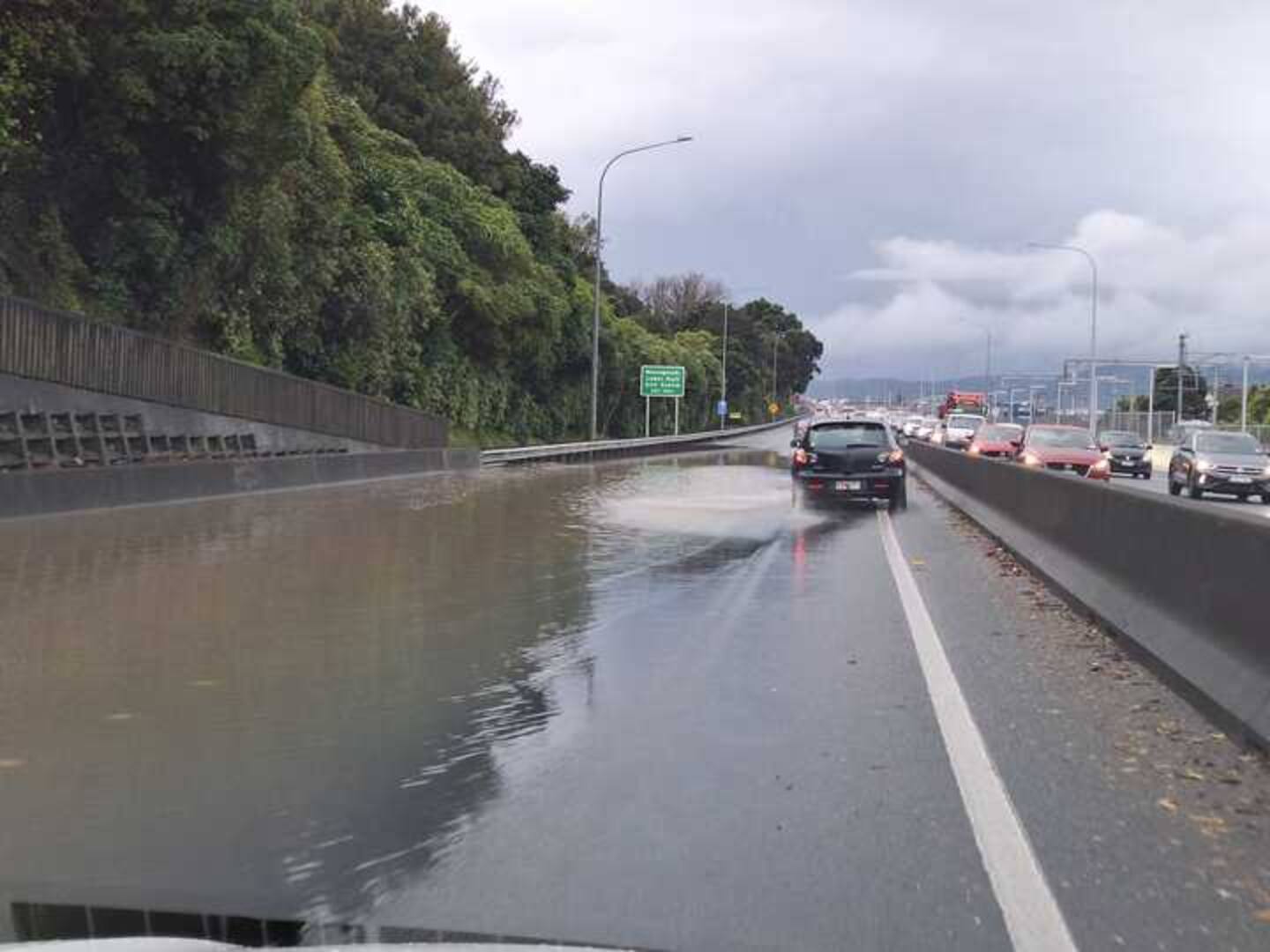
Flooding on SH2 northbound.
In Naenae in Lower Hutt, police have partially blocked off Cambridge Tce due to flooding across the entire road. A patrol car has blocked off northbound access.
Part of Strand Cres is also fully flooded with water spilling on to some properties. A local woman said while the area does flood at times it normally does not cover the entire road.
One resident was surprised to open her front door and see the flooding out on the road. She said she heard the heavy rain overnight but hadn’t realised the street was filling up.
Some cars can be seen driving through the floodwater, sending waves in to nearby properties.

Cambridge Tce in Naenae has been closed due to flooding. Photo / Melissa Nightingale

Flooding in Cambridge Tce, Naenae. Photo / Melissa Nightingale
A Hutt City Council spokesperson said it was continuing to monitor the Hutt River level as it continues to rise and rainfall forecast throughout the day and is ready to respond to any further developments.
A number of roads are closed in Lower Hutt, including Block Rd near Melling Station, Harcourt Werry Drive between Mills St and Percy Cameron Street.
There’s also surface flooding on Eastern Hutt Rd near the Silverstream rail bridge and people are being advised to avoid the area and find alternative routes.
The council has also received reports of wastewater overflow in some locations, and is urging people to stay out of floodwater as it may contain wastewater.

Flooding in Strand Cres in Naenae. Photo / Melissa Nightingale
Hutt Valley High School is closed today due to a burst water main. In a post on social media it said there was currently no water supply to the school.
Further north, the Judgeford Golf Club has been completely flooded and is closed until further notice.
In Porirua, officials met at 8.30am to discuss the situation with the council, Fire and Emergency, and Wellington Water. A council spokesperson said Wellington Water was clearing culverts in Whitby and East Porirua and added Fire and Emergency was “inundated”.
They said MetService is expecting 40mm of rain in the region across the next six hours - the main concern being around high tide at 2.19pm, with potential worries about the Pauatahanui Inlet.

The Judgeford Golf Club has been closed until further notice due to flooding. Photo / Judgeford Golf Club
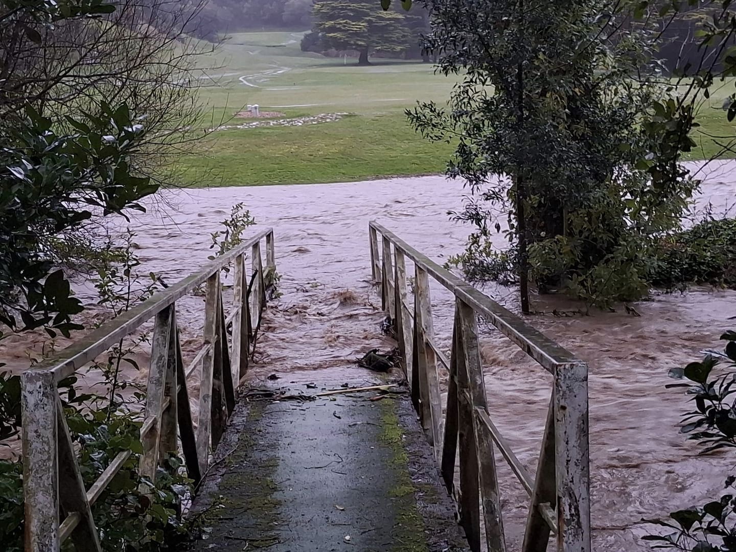
Floodwaters at the Judgeford Golf Club. Photo / Judgeford Golf Club
Man and his dog rescued
A man and his dog have been rescued after their vehicle became stuck in rising floodwaters near Porirua this morning.
FENZ shift manager Belinda Beets says one traveller earlier today found himself caught out by the weather when his vehicle got stuck on a flooded Grays Rd in Pauatahanui.
He called for help but, by the time firefighters were en route to the scene, a member of the public in a 4WD vehicle had rescued the man and his pet out of the car.
”I just think he was very lucky,” Beets said. “And good one, the person that stopped to help.”
People urged to ‘remain vigilant’ with more heavy rain to come
MetService said a Heavy Rain Warning is in place for Wellington and the Kapiti Coast with 50 to 70mm of rain expected in the 12 hours until 6pm Monday. Thunderstorms are also possible, with peak rainfall rates of 15 to 25mm/h.
The weather agency said streams and rivers may rise rapidly and the rain could cause surface flooding, slips and difficult driving conditions.
WREMO Regional Manager Jeremy Holmes said people should delay travel or work from home if they can with the wild weather set to continue for the whole day.
“Remain vigilant and, if you see flooding, please do not try to drive, walk or play in it. Keep an eye on the roads around the region and visit NZTA before you travel.”
Melissa Nightingale is a Wellington-based reporter who covers crime, justice and news in the capital. She joined the Herald in 2016 and has worked as a journalist for 10 years.
Azaria Howell is a Wellington-based multimedia reporter with an eye across the region. She joined NZME in 2022 and has a keen interest in city council decisions, public service agency reform and transport.
Take your Radio, Podcasts and Music with you