Police are warning people to drive to the conditions this evening, with three crashes reported on Auckland’s motorway network ahead of thunderstorms and expected disruption to the harbour bridge.
Thunderstorms are expected to rumble across the top of the country, hitting Auckland during evening rush hour as a large system packed with heavy rain and wind gusts bears down.
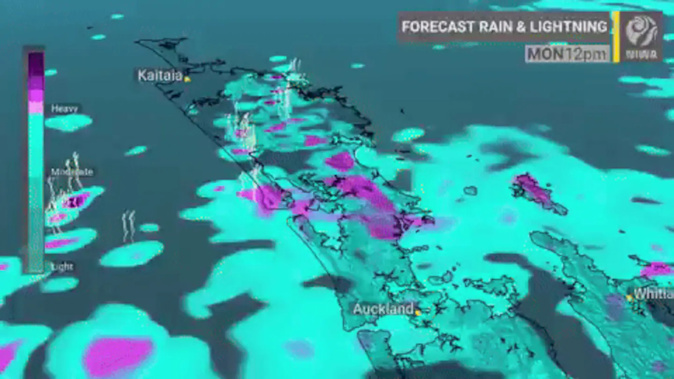
Bands of electrical storms are set to start at the top of New Zealand from midday and move south across the afternoon.
Strong wind may force the closure of Auckland Harbour Bridge, the New Zealand Transport Agency (NZTA) said. Otherwise, the agency said it would likely reduce speed limits and close lanes.
“Motorists are urged to drive to the conditions and look out for the electronic message boards which will indicate lane closures or full closures and reduced speeds, and stay within their lane while travelling across the bridge,” the NZTA said.
“Drivers of high-sided vehicles and motorcyclists are advised to avoid the Auckland Harbour Bridge and use the western ring route.”
Police issued a statement at 3pm telling motorists to drive to the conditions: “Traffic across the network is building following a four-car crash in the Waterview Tunnel and another involving two vehicles on the same stretch of State Highway 20 in Manukau.
“At least one northbound lane [was] closed following the crash in the Waterview Tunnel. Police were also notified of a two-vehicle crash on State Highway 20 southbound, near Cavendish Drive.
“A two-car crash northbound on State Highway 1 near the Khyber Pass off-ramp has also been reported.
“Drive to the conditions, slow down, [and] allow extra time to arrive safely at your destination.”
Forecasters are warning those living in northern regions to be prepared for localised heavy downpours that may cause surface flooding and rivers to suddenly rise.
MetService meteorologist Mmathapelo Makgabutlane said the northern areas of Auckland are in the firing line for the thunderstorms.
MetService has placed a heavy rain watch on the Auckland region, which is expected to end at 4pm.
The forecaster said thunderstorms were “likely to develop” following the heavy rain and could be accompanied by strong wind gusts of 90km/h.
Forecaster Niwa reported some thunderstorms may have a “stronger wind type”.
Makgabutlane said the thunderstorms would be “localised”.
“There will be pockets of heavier rain in the broader area.”
She said it would mostly affect commuters heading over the harbour bridge and beyond.
“The further north, the higher the chance for some thunderstorms.”
Makgabutlane said the ridge of high pressure that graced the city with clear skies last week had been replaced with a low-pressure system, which was causing the rainy conditions.
She said this was a fast-moving weather system and the majority of the rain will have moved off the Auckland region overnight.
Makgabutlane warned Aucklanders that the rain will not be gone for long and they should not be so quick to put away their umbrellas.
“We are looking at bands of rain.”
She said the weather would be a “mixed bag” this week, with pockets of settled weather mixed in with periods of showers for all regions across the city.
MetService said “it’s the weekend forecast that ... people [should] keep a very close eye on”, with strong winds, heavy rain and dangerous coastal conditions expected about the northern and eastern areas of the North Island.
Meanwhile, a heavy rain warning is in place for the Coromandel Peninsula, which is expected to last until 10pm tonight.
MetService reported the region should expect 70 to 100 mm of rain, with possible thunderstorms this afternoon.
A heavy rain warning will come into effect for Bay of Plenty at midday today. MetService is warning of surface flooding and slips, making for difficult driving conditions.
MetService told residents to expect 80 to 110 mm of rain inland and 50 to 80 mm of rain about the coast. There is a “minimal chance” of the warning being upgraded to red.
Northland is also under a heavy rain watch, which is expected to last at 4pm. MetService said there was a “moderate chance” of this being upgraded to a warning but thunderstorms are likely to develop.
A heavy rain watch will come into effect for the Tasman District at 3pm this evening as the low-pressure system moves down the country.
Rachel Maher is an Auckland-based reporter who covers breaking news. She has worked for the Herald since 2022.
Take your Radio, Podcasts and Music with you