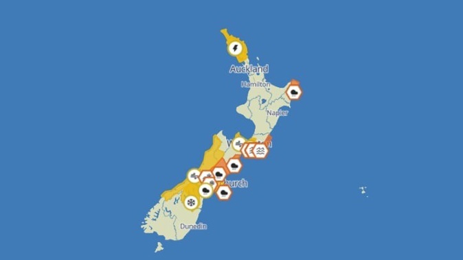
Thunderstorms and downpours are hitting the top of the North Island and heading for Auckland, while the other end of the country is preparing for plunging temperatures and a dumping of snow.
“Some areas may see periods of intense rainfall. Northland has already had a very wet month, and with soils already quite saturated, any further heavy rain could lead to impacts being felt more readily,” MetService said.
The top of the North Island has a forecast of 14 hours of lightning and intense rainfall until midnight tonight. The storm is then due to move to Gibsorne, which has a forecast of 12 hours of heavy rain until midday tomorrow.
Marlborough and Wellington are tipped to get 30 hours of high winds and heavy rain from midnight tonight.
Heavy swell warnings near the Cook Strait from Wairarapa to Wellington have already prompted ferry operator Bluebridge to prepare customers for potential delays or cancellations.
Meanwhile, heavy snow is expected in the Canterbury high country, where snowfall could hit warning criteria, from 6pm Wednesday to 10am Thursday.
MetService has issued road snowfall warnings for Porters Pass and Arthur’s Pass (State Highway 73) for Wednesday night.
Heavy rain warnings have also been issued for Banks Peninsula, North Canterbury to Hamner, and the Kaikoura coast and ranges, until 6am Friday. Mid-Canterbury also has a heavy rain watch. The West Coast will also fall under a strong wind watch until 3pm Thursday.
Flooding, slips possible, warns MetService
Northland is under a heavy rain and severe thunderstorm watch, with MetService warning it could cause surface flooding, slips, and fast-rising rivers.
Gisborne is expected to see as much as 25mm of rain an hour on Wednesday morning, with MetService saying the orange warning in place could be upgraded.
A strong wind watch for Marlborough and Wellington, along with a strong rain watch for the capital, had the potential to down trees and powerlines and lift unsecured property. MetService said motorcyclists and motorists, especially those in high-sided vehicles, should take extra care.
7m waves near Cook Strait
Ferry operator Bluebridge said conditions on Cook Strait were expected to deteriorate on Wednesday morning.
“If the large swells do eventuate, this may result in the delay or cancellation of services on Wednesday, Thursday and Friday.”
MetService said waves could reach as high as 7m on Thursday afternoon.
Daily highs to drop to single digits
Daily high temperatures are expected to drop to single digits in southern parts of the country as the Canterbury high country sits under a heavy snow watch.
Queenstown was expected to dip from 17C today to 8C on Thursday. Christchurch will drop to 10C on Thursday.
Auckland, meanwhile, does not have a forecast high temperature below 18C for the next week.
Raphael Franks is an Auckland-based reporter who covers breaking news and local stories from Tāmaki Makaurau. He joined the Herald as a Te Rito cadet in 2022.
Take your Radio, Podcasts and Music with you