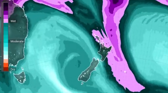
A mix of rain and humidity is set to spread across the country this week as “fingers of tropical moisture” reach down and touch New Zealand.
The recent fine weather has been thanks to high pressure sitting over the country.
However, this will begin to move east tomorrow making way for the humid air which is making a beeline here from the tropics.
Niwa weather said after a rather cool start to summer many parts of New Zealand would be sweltering in wet, muggy conditions.
“Fingers of tropical moisture are commonly expected to reach down and touch New Zealand in the coming week,” tweeted the forecaster.
MetService meteorologist Jessie Owen said a complex trough and northerly flow would see days of rain, with some spots in for heavy downpours.
Rain was set to hit the top half of the North Island tomorrow and the eastern areas of the island would be peppered by showers.
Owen said there will be a low risk of heavy rain from Auckland, Coromandel and the Bay of Plenty from Wednesday onwards.
Humidity levels were going to be higher than normal across the country.
In Auckland and Hamilton, the levels of humidity for today and tomorrow is 90 per cent while in the South Island the levels are at 100 per cent for Timaru and 96 per cent for Invercargill.
It would be mostly cloudy across the South Island tomorrow, especially inland. said Owen.
The rain was expected to ramp up across most of the country on Thursday with a low risk of heavy rain also possible for the West Coast of the South Island.
Owen said there was also a low risk of heavy rain on Saturday for Taranaki.
She also reported that most of the country’s temperatures are gradually rising and by the end of the week they would sit at mid to high twenties with some areas on the eastern coast of the North Island, including Napier, getting up to around 28C.
NIWA reported that belts of humid weather are going to be more common this summer due to an ocean-atmosphere phenomenon called La Niña.
Traditionally, La Niña has delivered more north-easterly winds that bring rainy conditions to North Island’s northeast, and drier conditions to the south and south-west of the South Island.
Thanks to the north-easterly winds, warmer temperatures also tended to play out over much of the country during La Niña, although there are always regional and seasonal exceptions.
NIWA said La Niña is creating warm seas in the southwest Pacific which are causing rising air and storminess, weather which is expected to sometimes reach while in a La Niña state.
This is the third time that New Zealand has seen a La Niña summer in as many years, dubbed by meteorologists as a “triple dip” – which has only ever been observed over 1973 to 1975, and most recently from 1998 to 2000.
Take your Radio, Podcasts and Music with you


