A weak atmospheric river is set to wash over much of New Zealand today and tomorrow, with some parts set to see 15 hours of non-stop rain.
There are already heavy rain warnings for parts of the South Island, and heavy rain and strong wind watches are in place for Wellington’s Tararua Range and Remutaka Hill Road and Mt Taranaki.
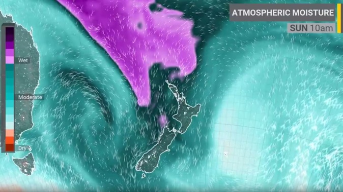
MetService predicted a burst of heavy rain and northerly gales from the west during Sunday and Monday.
NIWA called this weather system an “atmospheric river”.
Heavy rain is forecast for the Nelson and Tasman districts from early today until early tomorrow morning.
Residents should expect between 90-170mm of rain all day with peak rates of 15-25mm/h this afternoon.
Heavy rain may cause streams and rivers to rise rapidly. Surface flooding and slips are also possible and driving conditions may be hazardous, MetService said.
A strong wind watch is forecast for the lower North Island, including the capital, for 15 hours starting from 3pm.
NZ Transport Agency Waka Kotahi in the Nelson, Tasman and Malborough districts said MetService was predicting heavy rain between Upper Takaka and Collingwood and urged drivers to take care.
“Please remember to switch on your lights, increase your following distance & be prepared for unexpected hazards.”
The South Island’s West Coast residents are forecast to see between 120mm and 150mm of heavy rain from 8am to 11pm tonight, with peak rates of 12-25mm/h this afternoon and thunderstorms possible.
MetService said that on Monday snow is possible in the far south of South Island as low as 600 metres.
Earlier MetService meteorologist Mmathapelo Makgabutlane said a weather system would arrive from the northwest, bringing warm, moist air to the country, with the risk of severe weather.
“All the North Island and much of the South Island are expected to experience at least some wet weather as it moves across. Mountainous areas are likely to see the heaviest rain, but other regions could also be affected.”
Makgabutlane said the approaching system would also bring strong northerly winds.
“Areas such as Wellington, Marlborough, inland Canterbury, and the mountainous regions of the North Island could experience the strongest winds on Sunday and Monday.”
She said temperatures would also reflect the change in weather.
Sunday night into Monday morning would see many places with double-digit minimum temperatures, significantly higher than the seasonal norm, Makgabutlane said.
“Daytime temperatures will also feel unseasonably warm. Napier and Hastings are projected to reach 22C on Monday, due largely to strong northwesterly winds rather than abundant sunshine.”
Take your Radio, Podcasts and Music with you
Get the iHeart App
Get more of the radio, music and podcasts you love with the FREE iHeart app. Scan the QR code to download now.

Download from the app stores
Stream unlimited music, thousands of radio stations and podcasts all in one app. iHeart is easy to use and all FREE