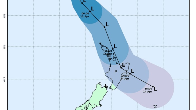
A tropical cyclone is on a direct path to New Zealand, according to a new MetService tracker.
Severe gales and storms are expected to hit parts of the country in the coming week – particularly the North Island – as tropical cyclone Fili makes its way south.
MetService says it is closely monitoring Fili as it tracks southeast from New Caledonia – with predictions that severe weather could hit New Zealand as early as Tuesday.
In the meantime, weather experts say they would be "hard pressed" to find any wet weather today, but that's just the calm before the storm.
"Latest satellite imagery shows mostly fine conditions over NZ today, just some cloud in places, and the odd shower. Enjoy it while it lasts, as Cyclone Fili moves towards NZ from Tuesday," MetService said in a tweet this morning.
According to WeatherWatch, most of the country can expect a sunny afternoon today with highs in the high teens or low 20s with the warmest spot being the Upper North Island, Waikato through to Northland.
"With an anticyclone in control we are pretty hard-pressed to find any wet weather today," WeatherWatch said.
The low-pressure system is still on track to move over the North Island on Tuesday or Wednesday.
"At this stage the upper North Island sees heavy rain move in from the north...with strengthening easterly quarter winds, gale force winds look possible in areas exposed to the east." WeatherWatch said.
"Then overnight and into Wednesday the low drops south over the North Island with heavy rain possible in the west and south of the North Island, potentially the upper South Island also."
It said the ex-cyclone has the potential to power back up into a storm, bringing severe gales and possibly heavy rain of more than 100mm or 150mm in some localised areas on Tuesday and Wednesday.
The low will be moving quickly over the North Island with wind and rain shifting around throughout its passage, which means some areas may have quite low rainfall while others nearby have larger amounts.
The forecast is for conditions will start to ease on Thursday when the low gradually moves away.
MetService said there was still a lot of uncertainty with the intensity and the position of the low as it moves towards New Zealand.
It may issue severe weather watches or warnings closer to the event.
Today's weather:
Northland: Cloudy at times, with isolated showers clearing this afternoon.
Auckland, Coromandel Peninsula, Gisborne, Hawke's Bay and Wairarapa: Mostly fine. The chance of a shower about Coromandel Peninsula this afternoon.
Waikato to Wellington, including Bay of Plenty and the central high country: Mainly fine. Cloudy periods from Manawatu to Wellington, and isolated showers in Waikato and Waitomo this afternoon.
Buller and Westland: Cloudy periods and isolated showers, mainly north of Hokitika.
Nelson, Marlborough, Canterbury, and Otago excluding Clutha: Fine, apart from cloudy periods about the east coast and Marlborough Sounds.
Clutha, Southland and Fiordland: Fine inland, but cloudy in the south and about the fiords, with isolated showers. However, becoming fine in Southland and Clutha this afternoon.
Chatham Islands: Passing light showers.
(Source: MetService)
Take your Radio, Podcasts and Music with you


