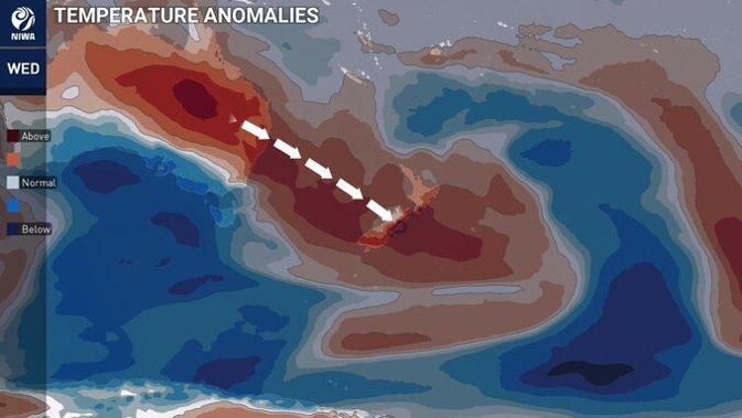
Rain is set to dampen outdoor plans for Labour Weekend as a plume of tropical moisture strikes the country beginning today.
Flooding is possible in the South Island as above temperatures melt snow ahead of wet and rainy days.
MetService meteorologist Clare O’Connor said anyone looking for a warm, sunny Labour weekend should head to the East Coast.
The rest of the country will be out of luck if they wish to spend the long weekend lounging on the beach, especially on Saturday.
“A lot of the country had a good weekend last weekend, it’s not going to repeat.”
Aucklanders should make indoor plans for the weekend with rain and northerlies forecast for all three days.
MetService said a large trough of low pressure was likely to cover much of New Zealand on Saturday, with northerlies affecting the North Island and southerlies developing over the South Island.
“There’s considerable uncertainty regarding the areas most affected, however, heavy rain could affect many parts of the country.
“Consequently, there is low confidence that heavy northerly rain could reach warning criteria about eastern Bay of Plenty, Waitomo, Taumarunui, Taranaki, Kāpiti [including the Tararua range], Wellington, Marlborough, Nelson/Tasman and northern Buller.”
O’Connor said Saturday will see the worst of the weather, Sunday the rain will ease off “a little” and ease again on Monday, but it will still be rainy.
She said the best of the weather will be in the lead-up to the weekend for most.
O’Connor said there will be highs of 26C to 27C in Hawke’s Bay on Thursday and Friday – Hawke’s Bay Anniversary day – and lows of 13C and 16C.
High temperatures will continue around the country, however, O’Connor warned this is not positive news for everyone.
The lead-up to Labour Day will be wet for Southland as a plume of tropical moisture strikes.
She said in Southland there is a risk of the snow melting on the mountains, filling up the rivers and catchments ahead of a few days of heavy rain.
“Especially the Otago area because they’ve already had so much moisture down there in the last couple of weeks already.”
A heavy rain warning will be in place for the headwaters of the Otago lakes and rivers for 24 hours after 4pm today.
“Heaviest falls are likely during Thursday morning when intensities of 15 to 25mm per hour are possible near the Divide,” MetService reported.
“Streams and rivers may rise rapidly. Surface flooding, slips, and difficult driving conditions possible.”
A heavy rain warning is also in place for Fiordland north of Doubtful Sound from 9am this morning until 3pm.
A heavy rain watch is in place for the Westland District and the headwaters of the Canterbury lakes and rivers.
Take your Radio, Podcasts and Music with you


