Damaging gales are set to blast central New Zealand in coming days, with a drop in temperatures that will feel more like autumn as a spell of wet and windy weather sweeps up the country.
But don’t despair - for many regions the hottest weather is still ahead and is likely to arrive around Waitangi Day.
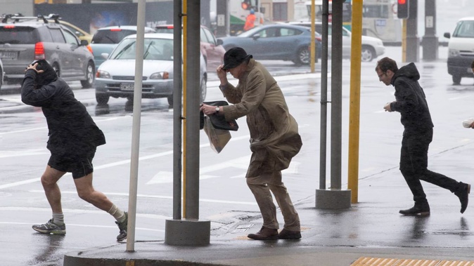
MetService meteorologist Alain Baillie said a strong cold front would move up the South Island tonight, with gales ahead of that front reaching Wellington on Friday, along with rain.
Gusts up to 100km/h were expected from the front. But it would move “reasonably quickly” and be off the country by the evening.
The government forecaster has issued heavy rain and strong wind watches which could be upgraded to orange warnings.
The Buller and Westland District ranges are currently under heavy rain watches from Friday morning, while Wairarapa, Wellington and the Marlborough Sounds are under strong wind watches for Friday afternoon and evening.
Private forecaster Weatherwatch.co.nz says the rough weather will last through Friday and Saturday with gales from the west to southwest.
“The next few days ahead will feel more like we’re in autumn as westerly winds roar through and temperatures drop. However it’s short lived – with settled weather by Sunday and Monday returning to NZ.”
‘Temperature rollercoaster’ ahead of Waitangi
Niwa says the next few days will put Kiwis on a “temperature rollercoaster.
“Unusually cool and brisk weather” is arriving for the first few days of February, but by Waitangi Day hot air will arrive from across the Tasman, potentially bringing the hottest weather of the summer for some areas.
MetService’s Baillie said above-average temperatures were likely in the South Island, with high 20s to low 30s in Marlborough and Canterbury.
Blenheim’s forecast high on Monday was 33C, while Oamaru’s forecast high was 28C - both 9C above the February average. Dunedin could expect 28C on Monday - 8C above average - and Ashburton was set for 32C.
The North Island would also be warm but “within a few degrees of average”, Baillie said, with Gisborne and Hastings headed for around 30C on Tuesday.
Auckland has already had one of its hottest stretches in years, with heat alerts issued amid humidity and temperatures close to 30C.
Niwa said Albany on the city’s North Shore reached 29.6C and Western Springs hit 29.3C - the hottest it had been since February 2020.
Take your Radio, Podcasts and Music with you
Get the iHeart App
Get more of the radio, music and podcasts you love with the FREE iHeart app. Scan the QR code to download now.

Download from the app stores
Stream unlimited music, thousands of radio stations and podcasts all in one app. iHeart is easy to use and all FREE


