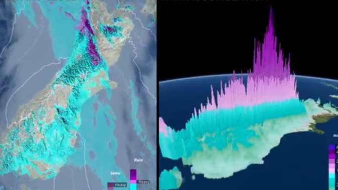
- Flights are disrupted with strong wind and rain forecast around New Zealand until tomorrow.
- Weather warnings cover the South Island and Wellington, with up to 200mm of rain expected.
- MetService says most of the North Island misses the severe weather.
A storm is disrupting flights across New Zealand today, with strong wind and rain forecast to batter the country until tomorrow.
Nearly the entire South Island, and Wellington, is under weather warnings and watches, with up to 200mm of rain expected in 20 hours in some areas.
And it is a sudden and dramatic turn, with some centres dropping in temperature by as much as 21C from today to tomorrow.
Meanwhile, in the North Island, fine conditions and temperatures in the high 20s were forecast for the Hawke’s Bay and cloudy showers for elsewhere.
Air New Zealand’s chief operating officer Alex Marren said several flights were disrupted in the South Island this morning due to the weather conditions.
“[This includes] high winds, low visibility and rain at several airports,” Marren said.
“We recommend customers travelling today keep an eye on the Air NZ app and the arrivals and departures page on our website for the latest updates. We’d like to thank our customers for their patience,” Marren said.
‘Watch for rising rivers, flooding and slips’ - Niwa
Flooding,slips and fast-rising rivers were possible across the West Coast and Southland today, the National Institute of Water and Atmospheric Research (Niwa) said.
MetService credited the sudden storm to “an active, potentially severe weather system”.
A heavy rain warning is in place for the Westland District and Fiordland, from 9am today until 6am tomorrow. MetService said up to 200mm of rain here was possible.
Southland and Steward Island were put under a heavy rain watch until 3am tomorrow. MetService said there was a chance this could be upgraded.
Strong wind watches were also issued for Wellington, the Canterbury High Country, the Canterbury Plains about the foothills, Otago and Fiordland, Southland and Stewart Island.
MetService said wind speeds up to 100km/h were possible in exposed parts of Wellington.
The dramatic plunge in temperatures will see Christchurch drop from a forecast 30C today to 9C overnight tomorrow.
The heaviest rain was expected later this evening into tomorrow, MetService said.
Auckland, meanwhile, had a mostly cloudy Monday forecast with a daily high of 25C and a few showers in the afternoon. Heavy showers were possible tomorrow morning, otherwise, fine conditions were forecast.
Raphael Franks is an Auckland-based reporter who covers breaking news. He joined the Herald as a Te Rito cadet in 2022.
Take your Radio, Podcasts and Music with you