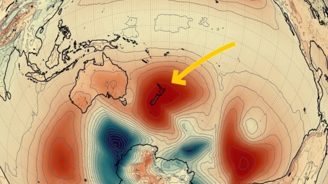
A giant high blanketing New Zealand is already breaking records for atmospheric pressure – while delivering frosty mornings for parts of the country.
Niwa meteorologist Ben Noll said the strongest high-pressure system anywhere on the planet was now centred over New Zealand – and it was likely to strengthen further tomorrow.
This week, barometers registered a new national mean sea level pressure record for July, reaching 1045 hectopascals (hPA).
“According to our national climate database, the national mean sea level pressure record is 1046 hPa, occurring a few times in recorded history and as recently as June 2016 in the South Island,” Noll said.
“The high pressure system over the country is set to peak in intensity tonight and tomorrow, potentially breaking this record.”
According to MetService, local air pressure hasn’t climbed above the 1040hPa mark since October 2022.
Noll explained that air pressure represented the force exerted by the weight of air above a given point on the Earth’s surface.
The current world record for high pressure was 1083.8 hPa, set in Siberia in 1968.
In systems like the one over New Zealand now, atmospheric pressure was higher than in the surrounding regions.
“In a high-pressure system, air descends and spreads outward, typically leading to clear skies, calm conditions, and stable weather,” Noll said.
In Hunua near Auckland, temperatures hit 17.2C today – having hit a chilly 3.2C less than 12 hours before.
Further south, the mercury plunged to –3.9C in Alexandra overnight, and has barely made it above freezing point throughout the day.
“While there is certainly a lack of precipitation, some folks may be awakening to foggy or frosty conditions.”
In parts of Central Otago like Alexandra and Clyde, Noll said a phenomenon called an inversion could even cause the fog and freezing temperatures to last all day.
“We’ll be watching closely.”
The run of settled, sunny weather for much of the country was forecast to take a turn beyond the weekend, with rain forecast early next week in centres including Auckland, Hamilton, Tauranga and Wellington.
Noll said the big high came amid a noticeable lack of local influence from the polar jet stream – a belt of fast-flowing air circling the latitudes deep below New Zealand.
“After frequently being located near the country during autumn, the polar jet has found itself buried deep in the Southern Ocean during winter as a La Niña-like pattern builds.”
Noll said the jet might strengthen in late July as the Madden-Julian Oscillation – an eastward moving “pulse” of cloud and rainfall near the equator that typically recurred every 30 to 60 days – swung eastward from the Indian Ocean.
Jamie Morton is a specialist in science and environmental reporting. He joined the Herald in 2011 and writes about everything from conservation and climate change to natural hazards and new technology.
Take your Radio, Podcasts and Music with you


