It is just a regular day at Mount Maunganui main beach when the ground begins shaking — hard.
The earthquake brings powerlines down on cars and people on the coast must act quickly.
As they scramble up Mauao, the ocean starts rushing out, sucked away from the coastline.
A tsunami is coming.
That’s the unlikely — but not impossible — scenario virtually brought to life in a new animated simulation Bay of Plenty beachgoers have been invited to experience this summer.

A still image showing a tsunami swamping downtown Mount Maunganui. Image / SkillsVR.com
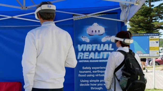
Tauranga emergency management staff will be visiting coastal hotspots between December and February, giving people a chance to test their decision-making in a natural disaster.
A 10-minute simulation via a virtual reality (VR) headset allows users to experience the predicted impacts of an earthquake and 9-metre tsunami on the Mount Maunganui coastline.
According to Emergency Management Bay of Plenty, more than 110,000 people across the wider Bay of Plenty coast live in tsunami evacuation zones, with more than half of them in Tauranga.
They, and anyone else in the zone, would need to head for higher ground if a long or strong earthquake hit — potentially the only warning they might get in time of an incoming tsunami.
Council-developed maps updated in 2023 identified kilometres of coastal evacuation zones in Tauranga based on a “maximum credible tsunami wave” of 14m, generated by a magnitude 9 or higher earthquake along the Kermadec Trench. Only a “rare” tsunami, however, would be big enough to wash over the dunes.

An example of tsunami evacuation zone maps prepared suburb-by-suburb for Tauranga. Image / Supplied
Isaac Orchard works as a community resilience advisor in the emergency management team at Tauranga City Council. He said he had noticed the need for more hands-on education around earthquakes and tsunamis.
“When talking about these low-likelihood events, they don’t happen very often, so it’s very hard to convince the community that they are real and these are what the effects could be.
“It’s very hard to fathom a 9m tsunami, but by putting the headset on and seeing it end at the top of the third storey of these buildings, it makes it very real and in that way, you can see the effects in a very safe environment.”
The simulation doesn’t require standing, jumping or walking, making it accessible to almost anyone — but it is not recommended for children under the age of 12 due to the distressing scenes.
Orchard said nothing like the simulation had been built in New Zealand before.
“We contracted a company called Skills VR, they’re the experts in building the simulation, but it took us about two months of development, and then it took them about four-and-a-half months to build it.
“We worked with behavioural scientists from the Institute of Geological and Nuclear Sciences [GNS] with developing [it] because there’s no other place in New Zealand that’s ever developed anything like this.”

Isaac Orchard, Community Resilience Advisor at Tauranga City Council, said there is a need for more hands on education around earthquakes and tsunamis. Photo / Kaitlyn Morrell.
He said it simulates a small earthquake and then a large earthquake, which you are asked to take action for.
“You’re asked what the safest action is, so drop cover and hold.
“Then, as to be expected after a large earthquake, you’re then moved into a tsunami situation and you’re asked to take safe action, which is to move to the highest point around.”
This summer, the community has the opportunity to put to the test what to do in an emergency through the virtual reality simulation at the beach.
Orchard said there are very limited interactive learning means when talking about disaster education, and this is probably the best way to do it.
Review: Tsunami in virtual reality
I had an opportunity to try out the tsunami simulation before its public tour began.
I did not know what I was getting myself into when I first donned the headset.
The 10-minute simulation immersed me in a reality where I had to make decisions in response to both earthquake and tsunami scenarios.

Bay of Plenty Times reporter Kaitlyn Morrell experiencing the VR simulation.
The simulation did not need to be photo-realistic to set a confronting scene, even in a virtual environment.
I did not know the enormity of these events and the immediate impacts they could have until I saw what could happen.
The simulation took me through helping a mother and child nearby “drop, cover and hold” as the shaking began, then move to higher ground.
The rush of the ocean being sucked out in front of my eyes was a challenging sight, knowing what would follow.
A tsunami charged across the sand and smashed into buildings as I stood on top of Mauao.
A VR feature allowed me to take a closer look at the damage in the aftermath of the wave — smashed glass in an apartment, rolled campervans and cars.
Emergency management virtual simulation dates:
When and where the public will have opportunities to experience the VR tsunami training.
- December 19: Pilot Bay
- December 20: Mount Maunganui Main Beach
- January 7: Pilot Bay
- January 10: Mount Maunganui Main Beach
- January 16: Pilot Bay
- January 18: Mount Maunganui Main Beach
- January 23: Pilot Bay
- January 24: Mount Maunganui Main Beach
- January 30: Mount Maunganui Main Beach
Kaitlyn Morrell is a multimedia journalist for the Bay of Plenty Times and Rotorua Daily Post. She has lived in the region for several years and studied journalism at Massey University.
Take your Radio, Podcasts and Music with you


