The largest underwater landslide ever documented off New Zealand’s coast could have produced a tsunami up to 70 metres high and sent waves as far as eastern Australia.
That’s according to a just-published study that modelled the possible impacts of ancient submarine landslides off the North Island’s West Coast - one of which created a deluge of material measuring about 35 times the volume of Mt Ruapehu.
But one of the scientists behind the study stresses events of this scale would be “extremely rare” in New Zealand.
While only about seven per cent of tsunami events worldwide are triggered by underwater landslides, these sub-surface slips remain an important hazard for coastal communities.
When a large area of the seafloor is suddenly displaced, a resulting “drag down” effect creates a trough at the surface, before water rushes in and produces a swell - culminating in oscillations that violently propagate outward across the ocean.
/cloudfront-ap-southeast-2.images.arcpublishing.com/nzme/3CPDCMDS3FHIJLL3WYEI2POZCY.png)
This graphic illustrates how underwater landslides can trigger tsunamis. Image / GNS Science
One such landslide in 1998, initiated by a magnitude 7.0 earthquake, sent waves up to 15m high into a stretch of Papua New Guinea’s coastline, eventually claiming up to 2700 lives.
Although there have been no major recent occurrences in New Zealand, scientists have identified undersea canyons well capable of causing them - including those off Wellington and Kaikōura - and plenty of evidence to show how they’ve unfolded here in the past.
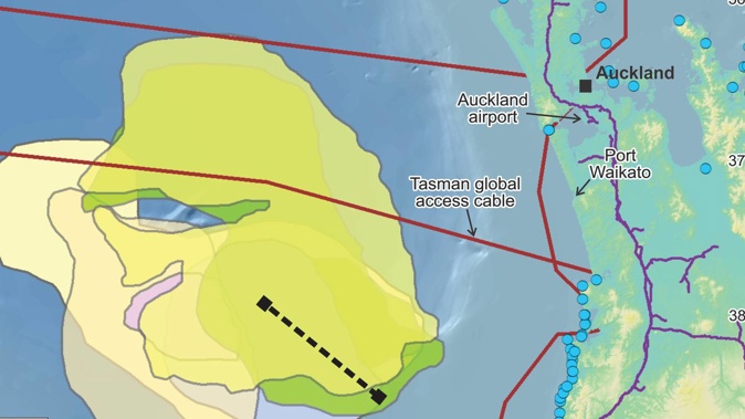
The latest study explored the tsunami-making potential of some historical landslides in the Deepwater Taranaki Basin, to the west of Auckland, which were discovered several years ago while scientists were mapping New Zealand’s offshore geology.
“We have a lot of geophysical surveys in the eastern Tasman Sea area from historical resource exploration,” said study co-author GNS geophysicist Dr Suzanne Bull, who’s been investigating the hazard with support from the Ministry of Business, Innovation and Employment’s Endeavour Fund.
“We didn’t actually know the landslides were there, so we stumbled across them in a sense.”
Seeing that they were exceptionally large, Bull and her colleagues at GNS and Australia’s University of Newcastle sought to learn more about them.
“We know that they are the biggest underwater landslides in New Zealand and [have] been happening around once every million years,” she said.
“They are related to large amounts of sediment being laid down on the continental shelf and slope, offshore Taranaki.”
When a lot of sediment was deposited in one area quickly, she explained, it created an “unstable pile” that could collapse and form undersea landslides - just as happened on land.
The largest mapped at the site was estimated to pack some 3500 square kilometres of material, or 35 times that of Mt Ruapehu’s volume.
/cloudfront-ap-southeast-2.images.arcpublishing.com/nzme/UHR5FYOH6FDRHP56CJHRNSVOZU.png)
This map shows the locations of six ancient and large underwater landslide events in the Tasman Sea recently discovered by scientists. Image / GNS Science
Such vast totals led the team to ask: would these landslides have sparked tsunami waves?
To answer the question, they drew on hydrodynamic models that predicted the behaviour of fluids.
“The landslides are modelled as a very dense fluid that moves downslope and is coupled to the water column above,” Bull said.
“So, as the landslide begins to move, the model also simulates any disturbance in the water, in this case the generation of tsunami waves.
“Finally, the model predicts how the waves propagate from the site of the landslide outwards - towards any nearby coastlines.”
The results revealed that even the smallest landslide the team modelled would have generated waves big enough to reach New Zealand’s coast and potentially cause damage.
The tsunami wave of the very largest, meanwhile, could have travelled across the Tasman Sea to reach Australia, with an 80-centimetre wave arriving 1km off Sydney some three hours after the landslide.
As for the impacts here, the calculations were staggering.
One scenario included a tsunami moving at a pace of 50m per second - and reaching the coastline with a maximum height of more than 70m.
At some parts of the west coast, the modelled arrival time was as little as 18 minutes after the event - and several low-lying regions were shown to be particularly vulnerable.
Still, Bull said such events were “huge but extremely rare” in New Zealand.
“We’re discovering more and more examples of underwater landslides around New Zealand from seafloor surveys, so we know they have happened a lot in the past,” she said.
“We know from this study and other events from around the world that such landslides can cause tsunami. But they are infrequent and unpredictable.
“So, while they are not something to lose sleep over, the concept of ‘maximum credible scenarios’ is an important one for scientists.
“Learning all we can from these past events helps us to be better prepared for what might come at us in future.”
Take your Radio, Podcasts and Music with you


