Days of heavy rain and strong winds will set in across the country from midweek, with severe weather alerts already issued for parts of the South Island.
Those wanting to make the most of the sun over the school holidays should do so today and tomorrow, as dry weather is expected until Wednesday, the National Institute of Water and Atmospheric Research (Niwa) said.
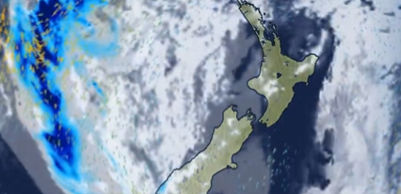
MetService’s five-day rain forecast imagery shows a mass of rain from the Tasman Sea slamming into Fiordland early Wednesday and fully enveloping the country on Thursday morning.
MetService meteorologist Lewis Ferris said it was “a bad start for the first week of the school holidays”.
Auckland can expect heavy falls and strong gusts on Wednesday before calming to showers on Thursday and Friday. All three days should hit 18C and 19C highs. Heavier showers are forecast for Saturday and Sunday, both of which should reach 20C.
The South Island’s West Coast, though, will bear the brunt of the large weather system. But Ferris also warned of a burst of rain in the Bay of Plenty, saying more rain is expected to fall in 36 hours from Thursday than through all of September.
MetService has issued heavy rain watches for Tasman northwest of Motueka for 9am Wednesday until 9am Thursday; Buller and Grey Districts for 6am Wednesday until 3am Thursday; Richmond and Bryant Ranges including the Rai Valley from midday Wednesday until midday Thursday; and Westland District from midnight Tuesday until midnight Wednesday.
“It’s likely that some of these watches will become warnings and areas around the North Island may be added,” MetService said.
The rain could cause streams and rivers to rise rapidly, surface flooding, slips and dangerous driving conditions, MetService said. The forecaster warned people to clear their drains and gutters to prepare and to avoid low-lying areas.
Snow is possible down to 500m in Otago and South Canterbury on Thursday, when a mass of cold air passes over the South Island.
Ferris said: “On Thursday, as a low-pressure system gets close to our shores, it drags in some cold air from the south of the South Island, and that’s lining up with the band of rain that brings the risk of snow.”
Take your Radio, Podcasts and Music with you


