A rare phenomenon unfolding over Antarctica could help spell a rocky change from winter to spring, as forecasters warn of possible damaging winds and thunderstorms for New Zealand this week. What’s going on? Jamie Morton explains.
Has our late-winter weather been a little on the unusual side?
If it’s seemed a little colder and wilder than earlier in the season, you’re not mistaken - and there’s an unusual reason behind it.
Meteorologist Ben Noll said New Zealand has been experiencing the distant influence of what’s called a “sudden stratospheric warming” (SSW) event over the South Pole.
This rare phenomenon - only observed in our hemisphere four times in the satellite era - happens when temperatures in the polar stratosphere heat up while wind speeds drop.
The result has been a hugely destabilised polar vortex, which has in turn made the wind-packed polar jet stream around Antarctica so “wobbly” it’s pushed out into the latitudes where New Zealand lies at times.
For people in the South Island, that’s helped make for some bitterly cold weather over the past few weeks.
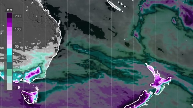
But next week, Noll says people in eastern areas could see a noticeable swing toward warmer temperatures, while southwestern regions are to be hit by several gusty rainmakers.
Is that all that’s going on?
Noll said the polar heatwave was only part of a dramatic and complex picture across the Southern Hemisphere right now.
“While we have this area of really high pressure going on over the South Pole, we also see this equal-strength but opposite-force low-pressure system forming over the Southern Ocean,” he said.
“And on the northern flank of that is a massive heat dome that’s developing over Australia.”
These contrasting patterns were also helping to drive a strong jet “streak” that extended from the Indian Ocean across southern Australia and into western New Zealand.
“For Australia, this could mean temperatures reaching over 40C next week - among the hottest winter temperatures on record there,” he said.
“For us here, it’ll likely be quite warm at times when some of those air masses from Australia reach our shores –-and we could be looking at temperatures in the low or even mid-20s in eastern areas of the country.”
Meanwhile, he said rain-packed fronts stemming from that large mass of low pressure to the southwest of New Zealand would spell more big downpours for the inland and western South Island over the next 10 days, with flooding possible.
The western and northern North Island were set to feel its effects too, with frequent showers and thunderstorms.
The whole country was set to experience rounds of strong to potentially damaging winds from late next week, which could impact flights, Noll said.
“Overall, the set-up of different pressure patterns around the hemisphere is making for a pretty rocky end to winter and start to spring.”
Is La Nina still on the cards?
Noll said right now, the biggest drivers shaping New Zealand’s weather were coming from the south, rather than the north.
However, up in the equatorial Pacific, forecasters have been watching for early signs of another La Nina climate pattern, which is expected to strengthen later in spring.
That pattern, which dominated New Zealand’s weather over the first three years of this decade, was notorious for delivering relentlessly moist and humid conditions to our northeast.
But Noll said the latest guidance suggested the next La Nina - if it did fully develop - wouldn’t be intense as those of recent years.
“Current indications are it wouldn’t match what we saw culminate over the summer of 2022-23.”
What that might mean for New Zealand’s summer outlook was still coming into focus, Noll added.
The National Institute of Water and Atmospheric Research (Niwa) is expected to release its outlook for spring this week.
Jamie Morton is a specialist in science and environmental reporting. He joined the Herald in 2011 and writes about everything from conservation and climate change to natural hazards and new technology.
Take your Radio, Podcasts and Music with you


