
New Zealanders are being urged to keep an eye on weather updates with heavy snow on the way for the south and thunderstorms for the north.
MetService meteorologist Alwyn Bakker said the heavy snow would fall in the south of the South Island.
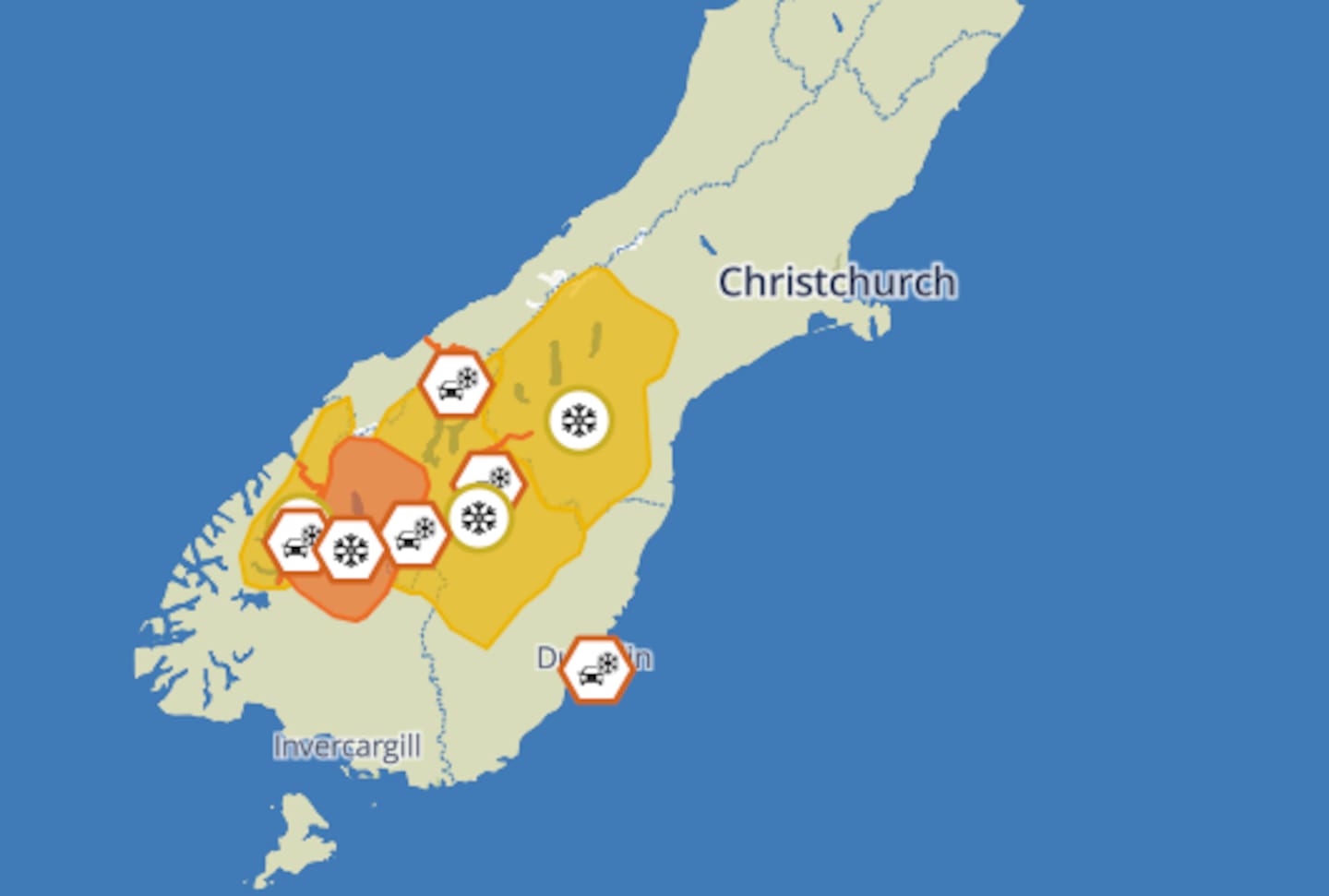
“We have warnings out for the Haast Pass, the Crown Range Road, Milford Rd and the Dunedin to Waitati Highway,” he said.
MetService also reported a high risk of thunderstorms in Northland on Monday afternoon, and a moderate risk for Auckland, with heavy rain in both areas.
There’s an orange snow warning in force until 10pm Sunday for Queenstown Lakes District south of Wanaka, and Southland, north of Mossburn and west of Athol, until 10pm.
There’s also an orange warning in force until 5am Monday in Southland north of Lumsden and from Athol eastwards, also inland Otago - excluding the Queenstown Lakes District.
There's snow forecast down to 600m in the lower South Island over the next 48 hours. Photo / MetService website
“We’re expecting snow down to about 400m,” Bakker said.
This could result in travel disruptions and damage to trees and powerlines.
“If you must travel, drive cautiously and ensure you have snow chains, sleeping bags, warm clothing, and emergency items,” Bakker said.
Throughout today, a front will move slowly northeast over the lower South Island, starting with moist northwesterlies and followed by a much colder southeast flow.
Overall, snow is predicted for Southland, Otago, and South Canterbury today, easing to scattered showers this week.
In a post online Niwa Weather said it’s a good day in the South Island “for snowman building, not for driving”.
“These cold conditions may cause stress to livestock ... farmers should prepare for snow, cold temperatures and possible power outages.”
There’s also a heavy rain watch in coastal Otago until 3am Monday.
North Islanders can anticipate southwesterlies, rising to gale in exposed places on Tuesday and snow to 600m about the central plateau for a time - moving to scattered showers later in the week.
Motorists are being advised to keep on eye on the New Zealand Transport Agency Waka Kotahi website for any road closures.
Sign up to The Daily H, a free newsletter curated by our editors and delivered straight to your inbox every weekday.
Take your Radio, Podcasts and Music with you


