More big deluges are possible before the end of winter as a returning La Nina climate pattern develops more quickly than forecasters had anticipated.
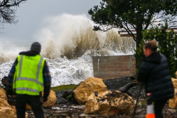
This week’s big rainmaker – a deep, moisture-packed low-pressure system that moved slowly over New Zealand – dumped more than 200mm on some parts of the East Coast within 24 hours.
As storm-battered regions began cleaning up after widespread flooding estimated to have caused millions of dollars of damage, NZ Transport Agency Waka Kotahi today confirmed all of Hawke’s Bay’s State Highways - bar SH38 between Frasertown and Lake Waikaremoana - were open.
The section of SH38 remained closed, but one lane was open to residents and emergency services only and traffic management will be in place.
In hard-hit Wairoa - where 400 properties had been affected by flooding, including more than 100 significantly - a local state of emergency remained in place.
In the background, meanwhile, forecasters have been tracking the formation of La Nina, a large-scale climate driver known to bring moist and humid conditions to New Zealand’s northeast.
 Crews continued to clean up flood-hit Wairoa on Thursday, where hundreds of homes received damage. Photo / Paul Taylor
Niwa’s just-issued outlook for the next three months picks a 60 to 70 per cent chance of that pattern, which dominated our climate for the opening third of this decade, developing during spring.
“We’ve been seeing a quicker pace of La Nina-like conditions developing, and what we saw on the East Coast of the North Island is indicative of that trend,” Niwa meteorologist Ben Noll said.
The wetter outlook marked a shift from the drier conditions that Niwa has been observing and predicting throughout the year so far, on the back of a now-faded El Nino system.
Between now and September, Niwa is picking rainfall near to above normal for the north and west of the South Island and near-normal amounts elsewhere.
It also points to the potential for another big downpour in mid-July, courtesy of a pulse of subtropical moisture called the Madden-Julian Oscillation, which also had a hand in this week’s storm.
Another important part of the picture, Noll said, was a fast-heating blob of ocean dubbed the West Pacific Warm Pool.
It has served as a potent source of moisture for rainmakers over recent years – including those that drenched the north over the extreme summer of 2023.
“Low-pressure systems are now drawing on that moisture in that source area, north of Australia, which has meant long moisture plumes and atmospheric rivers have become more prominent over June than we would have expected,” Noll said.
“We’re going to be keeping a close eye on that as we move through late winter and into early spring.”
Over that period, there was potential for more high pressure near the North Island and a possible return to the westerlies that proved relentless over summer and autumn.
 Residents muck in at storm-hit Haumoana this week. Photo / Paul Taylor
Temperatures were likely to be near or above average in all regions, with fewer winter cold snaps and frosts than normal.
“Those windows of cold weather are not going to be open very wide, which does make it a little frustrating for some of the ski areas,” Noll said.
“But that’s consistent with the trend we’ve been seeing over the last couple of winters as things get warmer and warmer – and having a La Nina developing in the background isn’t helpful.”
Jamie Morton is a specialist in science and environmental reporting. He joined the Herald in 2011 and writes about everything from conservation and climate change to natural hazards and new technology.
Take your Radio, Podcasts and Music with you