Weather warnings have been issued across the West Coast as drivers encounter flooded roads during the Labour Day long weekend.
Forecaster MetService has issued a strong wind watch for Westland and heavy rain warnings for the Buller and Grey districts, as well as inland and southern Marlborough.
MetService said teams in Buller and Grey districts are preparing emergency centres in anticipation of severe weather.
The ranges of eastern Bay of Plenty and Gisborne have also been given a heavy rain warning from 9pm tonight to 9am Sunday.
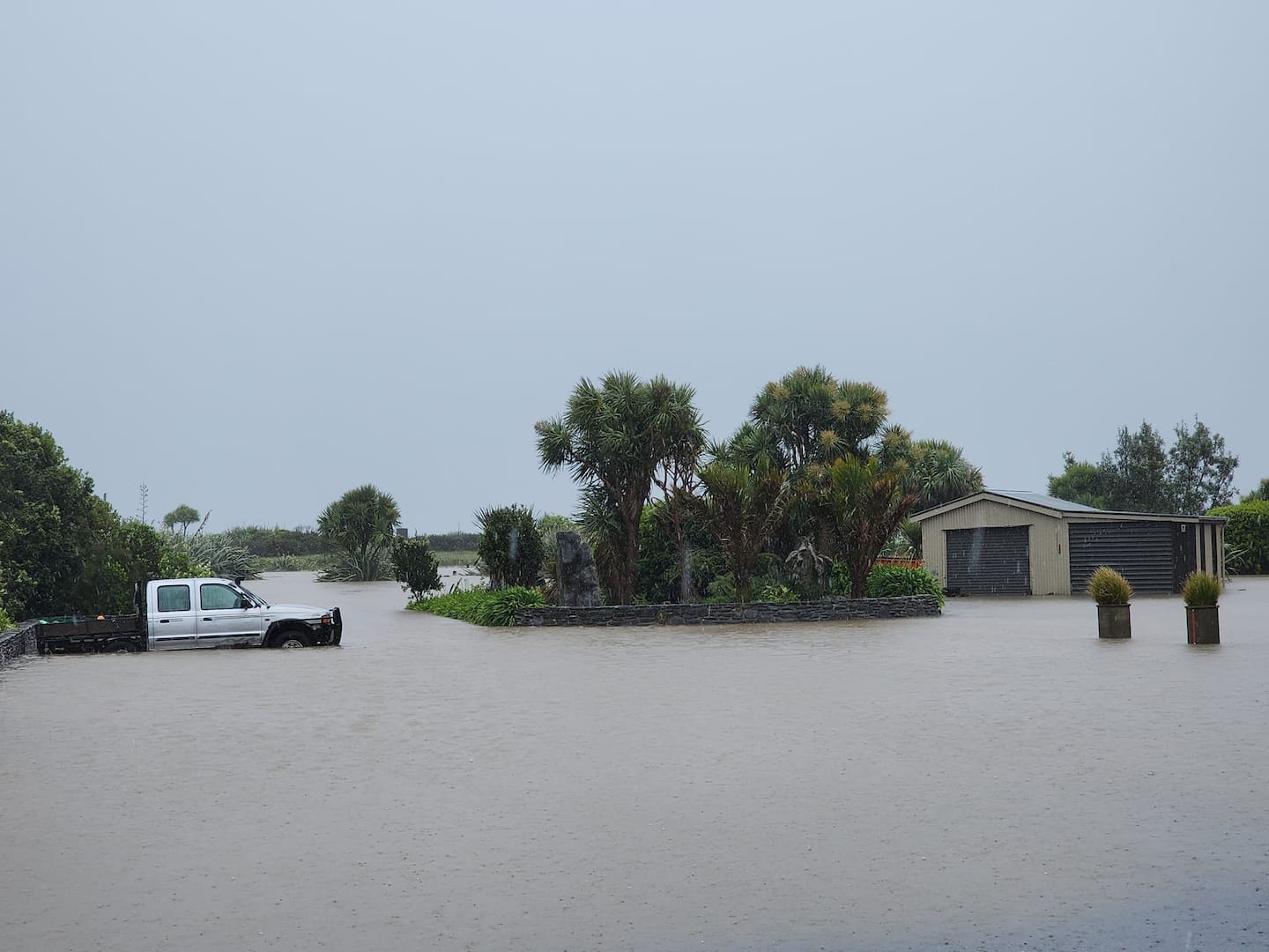 Flooding in Greymouth in the West Coast region. Photo / Tess Row
“Members of the public are advised to keep up to date with weather information as rivers may rise quickly, surface flooding and slips are possible and driving conditions could be hazardous,” said MetService group manager Claire Brown.
Pictures uploaded to social media show cars attempting to drive through flooded roads in Inangahua.
Several South Island highways have been closed, including State Highway 6 at Inangahua and SH7 from Kaiata to Stillwater.
Snow has closed SH73 between Ōtira and Arthur’s Pass Village and from Springfield to Arthur’s Pass (Porters Pass), and SH 80 between Lake Pūkaki and Mt Cook.
Forecasters said almost all of New Zealand was expected to experience rain on Saturday as holidaymakers flock north and south for Labour weekend.
MetService forecast that “most regions” would see a burst of heavy rain from late yesterday until Sunday morning as a band of heavy rain moves over the country.
Meanwhile, NZ Police and NZ Transport Agency Waka Kotahi (NZTA) have urged motorists to keep themselves and others safe this Labour weekend – after six people died on the roads during the holiday last year.
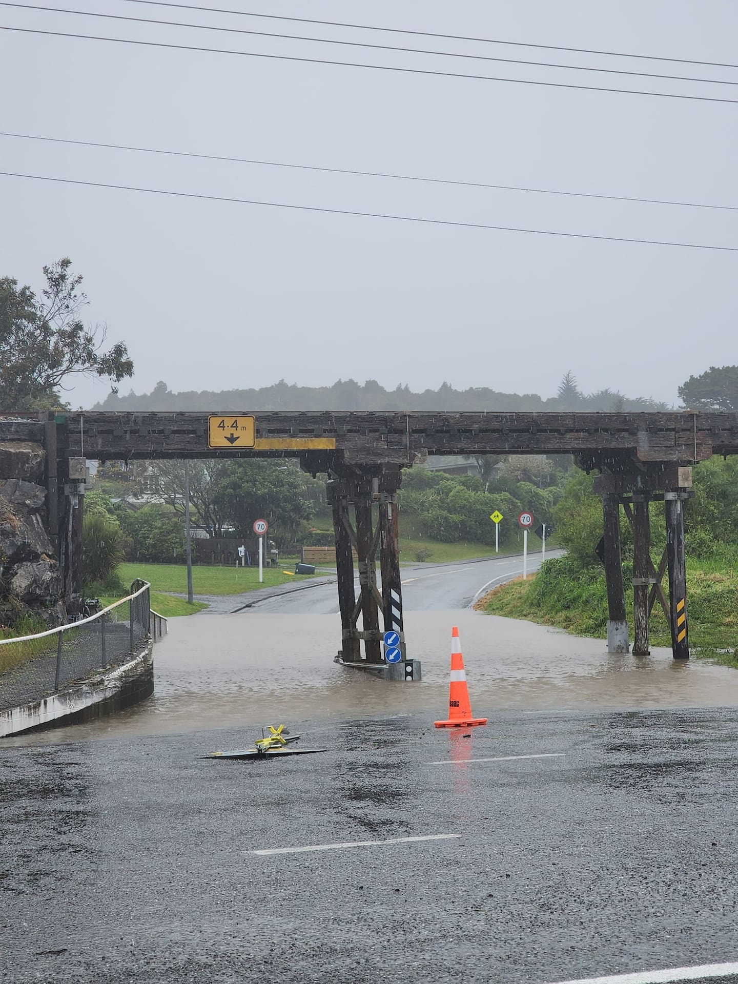 Rainwater pools under a bridge in the West Coast. Photo / Tess Row
NZTA director of land transport Brent Alderton said with more traffic comes the need to take extra care.
“Holiday traffic means there will be congestion on highways in and out of the main urban centres on Friday and Monday. We’re asking everyone to make safe choices to protect themselves and others.
“Please be patient and drive at a safe speed.”
The director of road policing, Superintendent Steve Greally, reiterated there was “no room for complacency” and said police were “determined not to see a repeat” of last Labour weekend’s six deaths.
Greally said staff would be working “tirelessly throughout the country” to make sure everyone stays safe.
“Those who blatantly choose to drive dangerously, whether it’s driving without a seatbelt or impaired by drugs and alcohol, using a mobile phone or speeding, they can expect to be ticketed.”
Forecasters said the country should be preparing for a wet Labour weekend and heavy traffic congestion over the coming days.
A raft of orange heavy rain warnings remain in effect for the Tasman District west of Motueka, the Richmond and Bryant ranges, the Rai Valley and Canterbury High Country this morning and are expected to lapse at 9pm today.
MetService warned up to 250mm of rain was expected about the ranges and alps, with much less forecast near the coast.
“Streams and rivers may rise rapidly. Surface flooding, slips, and difficult driving conditions [are] possible.”
A warning for the ranges of eastern Bay of Plenty and Gisborne was set to come into effect for 12 hours from 9am today, bringing with it up to 100mm of rain and a possibility of thunderstorms.
“Clear your drains and gutters to prepare for heavy rain. Avoid low-lying areas and drive cautiously,” MetService said.
MetService forecaster Luis Fernandes said “almost all of New Zealand” would experience some rain on Saturday.
“The South Island is particularly wet to start the day off and then the rain is spreading across the North Island as the day goes on,” he said.
“By late afternoon or early evening, just about all of the North Island will have had at least some rain.”
He said South Island residents would face a cold Saturday.
“Pretty much from Canterbury southwards, temperatures will be low. There could be snow down to 500 metres for inland Canterbury and parts of Otago, along with the wet weather.”
However, by Sunday, much of the low-pressure system forecast to soak the country on Saturday would weaken.
“We’re going to see showers in some places, especially in the morning,” Fernandes said.
“The rain then becomes confined to the western parts of the country. The west coasts of both North and South Islands, including Auckland down to Wellington and down to Southland, could continue to see a few showers.”
The system is forecast to weaken further and move off the country by Monday, but showers may linger in western parts of both islands.
Temperatures are set to linger in the low 20s for much of the North Island on Saturday.
“For Northland, Auckland and Waikato, we’re seeing 20C on average,” Fernandes said.
“But if you head towards the eastern part of the island, Hawke’s Bay, the Wairarapa, and places like Whanganui we’re likely to see temperatures in the mid-20s.
“Even towards Wellington, we’re seeing temperatures towards the 20C mark.”
On Sunday, temperatures are expected to drop.
“Hawke’s Bay and Gisborne will be reaching the mid-20s on Sunday, but elsewhere we will see a slight dip in temperatures from the high teens to the 20C mark.”
Take your Radio, Podcasts and Music with you


