A raft of severe weather advisories have been issued across the North Island, ahead of an incoming subtropical rain-maker that could cause slips and flash-flooding.
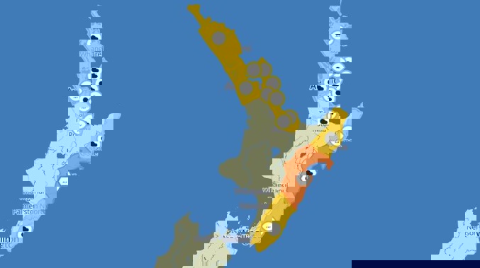
An orange warning is already in place for Hawke’s Bay, where 120mm to 160mm could fall between 6am Tuesday and 6pm Wednesday - with peak rates potentially reaching 15mm to 25mm an hour tomorrow morning and afternoon.
MetService warned this could cause rivers to rise rapidly, with the heaviest falls likely centred south of State Highway 5.
“Surface flooding and slips are also possible and driving conditions may be hazardous.”
Elsewhere, heavy rain watches are in place for Wairarapa and Tararua District (from noon Tuesday to 9am Wednesday); Gisborne/Tairawhiti (from 4am Tuesday to 6pm Wednesday); Bay of Plenty (from midnight to noon Tuesday); Coromandel (from 10pm tonight to 9am Tuesday); Auckland and Great Barrier Island (from 9pm tonight to 6am tomorrow); and Northland (from noon today to 1am tomorrow).
The heavy rain was coming courtesy of a subtropical low pressure system, currently forming north of New Zealand.
Strong easterly to southeasterly winds are also expected in the central North Island on Tuesday, with a possibility of severe gales about the ranges from the Raukumara to Ruahine ranges and further west.
Federated Farmers has welcomed the expected rain for Hawke’s Bay and Gisborne, where soils are very dry going into winter.
But MetService says there are concerns about flash flooding if too much rain falls on dry, hard ground.
MetService meteorologist Dom Barry said surface flooding across Hawke’s Bay was highly probable.
The system was “subject to change”, but current models showed a wet week ahead for the region.
”As time goes by, this warning may be extended. The current model run shows that rain could be seen throughout the whole working week,” Barry said.
”With these heavy downpours, we can expect to see some surface flooding. We need to make sure we get our people out there driving and staying safe when they are out and about.”
The forecaster said people should keep an eye out for upgrades to the forecast, as there was “uncertainty” about how the low-pressure system would develop and more areas could get severe weather watches or warnings.
Weatherwatch.co.nz said there would be at least two low-pressure zones affecting the weather - a “slightly messy set-up” which meant forecast rainfall totals could move around. Rain would be patchy in some areas but heavy in others.
However, most other parts of New Zealand would have a drier-than-usual week for the time of year.
Take your Radio, Podcasts and Music with you


