Gisborne District Council has turned to artificial intelligence (AI) to help control the woody debris that covers the region’s beaches after heavy rain events.
Council woody debris programme manager Rod Sheridan said woody debris in rivers and on local beaches was an unwelcome but expected sight after heavy rain.
There were initiatives under way to reduce the amount of debris and sediment entering waterways but they would take time to establish and come into effect.
“Our region has been fortunate to receive significant Government investment to help us reduce the immediate risk large woody debris poses to our community, critical infrastructure and the environment,” Sheridan said.
He said important lessons across extraction methods, project management, safety, environmental best practices and costings had been learned over the past two years of extracting woody debris.
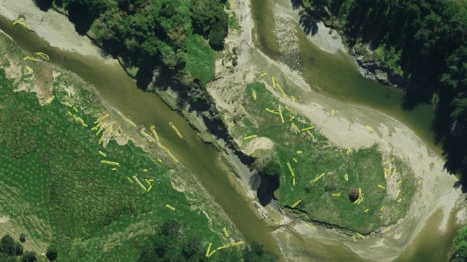
The council said in a statement one of the most significant recent advancements had been the integration of aerial imagery and AI technology into the programme.
High-resolution aerial imagery was captured across the entire region at the end of 2024 and will soon be available to the public online.
“Since capturing the imagery, the Large Woody Debris project team has been using a company specialising in AI to detect woody debris in or near our waterways,” Sheridan said.
The council said using AI technology had been a “game-changer” for the project because it was a smarter and more cost-effective way to quickly identify the location of woody debris and estimate volumes.
It allowed the team to get approval to remove the debris from entire catchments efficiently and helped with better planning and consistent work for contractors, according to Sheridan.
“Before AI, the process was incredibly time-consuming. We used older imagery and on-screen mapping techniques, but recent storms often changed the debris locations,” he said.
“We had to do site visits and use drones to capture images, then review them to decide whether to remove the debris or not. AI has quickly identified thousands of debris locations.”
Sheridan said while AI can pinpoint areas with a lot of debris, it cannot tell them how to manage it.
“We still use drone imagery to supplement AI results in critical areas and help make operational decisions.
“The use of AI and drone imagery not only speeds up the decision-making process but also ensures that we have a current and accurate view of the woody debris issues within the region.”
Sheridan said the integration of advanced technology into the Large Woody Debris Programme highlights the emerging benefits of having up-to-date decision-making tools.
“It showcases how technology can significantly enhance environmental management efforts, ensuring a cleaner and safer environment for all.”
As of the end of last week, 505,000 cubic metres of large woody debris had been successfully removed from Tairāwhiti waterways.
Take your Radio, Podcasts and Music with you