- MetService has issued “orange” warnings for heavy rain in Coromandel and north of Gisborne until late evening
- A Niwa forecaster says rain and humidity forecast about the North Island this week is unlikely to reverse unusual widespread dryness
- Dry conditions are likely to persist through February and into early March
Heavy downpours hitting parts of the north won’t ease unusual and widespread summer dryness that has set in across New Zealand, a meteorologist says — and there’s scant sign of much rain relief in coming weeks.
MetService has issued orange heavy rain warnings for the Coromandel Peninsula and Gisborne north of Tolaga Bay until late today, with 200mm having already fallen on Coromandel’s Pinnacles over the past 24 hours.
MetService meteorologist Katie Hillyer said the weather system meant muggy conditions over the North Island.
“Warm humid air with plenty of cloud cover acts like an insulative blanket, meaning warmer nights and uncomfortable sleeps this week.”
The weather was expected to shift south overnight, with 80mm to 100mm expected about the Tasman ranges between 9pm and 7am tomorrow.
“Thunderstorms could also be on the cards Tuesday afternoon and evening for Canterbury down to Southland, as well as Westland through to Buller,” Hillyer said.
“Cloudy and wet will be the real descriptors for much of the country until Thursday and into Friday, when a ridge of high pressure starts trying to push out that humidity and bring in some fresher air.”
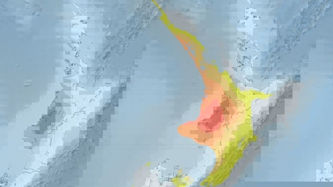
But that hit of moisture was not likely to turn around drying trends that have led to major soil moisture deficits around most of New Zealand.
Niwa’s Drought Index shows swathes of Taranaki, King Country and southern Waikato have entered mereological drought — with most of the western North Island otherwise running dry to extremely dry.

Source / Niwa
Niwa meteorologist Chris Brandolino expected those most parched areas would be receiving little of this week’s rain.
The lack of rain was being exacerbated by a high rate of potential evapotranspiration: or the amount of moisture lost to the atmosphere each day.
Brandolino estimated that areas in Waikato and Northland had been losing 5mm to 6mm of moisture a day over the past two weeks.
“If we’re losing five to six millimetres of moisture to the atmosphere... that’s 50 millimetres of rain you would need to take in to offset those losses, and we’re not going to do that this week,” he said.

Source / Niwa
“Unfortunately, as we look over the next two weeks, the opportunity for rain is not great — the remainder of February and early March looks unusually dry.”
Niwa’s median 35-day outlook also showed a risk of “very dry” conditions lingering in Taranaki, along with long stretches of the South Island’s West Coast.
“Perhaps, as we work our way well into autumn, there may be some opportunity for change,” he said.
“But certainly, as we close the books on meteorological summer, there’s no reason to believe there’ll be a profound shift in the weather pattern to bring rainfall.”
That would be of concern to farmers in affected areas, and also fire crews, with high fire danger now being observed in parts of Northland, Taranaki, Manawatu, Tasman, Canterbury, Otago and Southland.
Auckland’s dam levels were meanwhile running slightly below average for storage for this time of year — but still about 70% full.
Jamie Morton is a specialist in science and environmental reporting. He joined the Herald in 2011 and writes about everything from conservation and climate change to natural hazards and new technology.
Take your Radio, Podcasts and Music with you