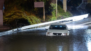
New Zealand’s cold and soggy start to the week is linked to the “death throes” of a long-lingering climate pattern that played a major role in the North Island’s disastrous summer.
A chilly southwest blast, preceded by strong northwest winds, is pushing up the country this afternoon, with Fiordland and Westland having already copped the front’s heaviest rainfall.
For meteorologists watching the wider picture, there’s some interesting – and in some cases, record-breaking – climate activity unfolding in the background, including the long-overdue demise of La Niña.
The ocean-driven system has been shaping our climate patterns since the start of the decade, contributing to the northeast’s warm, wet and wild summer, while helping push parts of the South Island into meteorological drought.
Its exit is now being hastened by a phenomenon unfolding in the tropics, called a “westerly wind burst”. where typical east-to-west trade winds across the equatorial Pacific switch to west-to-east.
That transition also happened to be a common sign of a forming El Niño: a system bringing the opposite climate flavour to La Niña, and increasingly likely to arrive later this year.
The burst is being influenced by the strongest particular phase of the Madden Julian Oscillation (MJO) - a driver we could think of as a freight-train of rain and thunderstorms, circling the globe every 30 to 60 days – observed in March since records began four decades ago.
“That’s phase eight, which, generally speaking, is associated with enhanced convection and thunderstorm activity in the eastern Pacific,” Niwa meteorologist Ben Noll said.
“And as that MJO pulse is moving over the eastern Pacific at the moment, it’s gathering strength.
“What we’re seeing is the strongest phase eight in the month of March on records going back to 1980.
- What's driving this wild weather? The swirling Pacific, La Nina, and warming
- Weather: Deluge expected to drench the country tomorrow
“That extra strength is changing circulation patterns at the equator, with profound downstream effects right across the Pacific – and the globe.”
In New Zealand, we’re seeing its influence in more westerly winds, which haven’t been observed here in great frequency for some time.
“So, in this case, the westerly winds coming across the country now are connected to what’s happening further afield, as climate patterns move away from La Niña.”
Noll noted the other two times where the MJO was behaving in March as it was right now was 2015 and 1997.
“As we know, late 2015 and early 2016 had a super-charged El Niño, while the El Niño we saw in 1997-1998 was also one of the strongest on record,” he said.
“So, while we wouldn’t go as far as saying we’re going to see the same thing happen later this year, the puzzle pieces we’re already seeing come together are making for an interesting picture.”
And the MJO effect wasn’t the only fascinating aspect of La Niña’s departure, or our current bout of cold weather.
The shift from La Niña is also expected to coincide with more negative phases of the Southern Annular Mode (SAM) - a ring of climate variability that encircles the South Pole, but stretches far out to the latitudes of New Zealand.
In its negative phase, westerly patterns, like those being seen today, increase over New Zealand – often bringing more colder and unsettled weather - while windiness and storm activity ease over the southern oceans.
Noll explained this week’s cold front was being caused by the clash of a deep low-pressure system in the Southern Ocean with a high to the north – in turn forcing the SAM to negative levels not seen since March 2017, and 2002 before that.
“So, having those pressure anomalies positioned as they are at the moment, very much pushes the SAM to the negative side of the spectrum – that of course, is tied up with fronts that we had last week and again now,” Noll said.
/cloudfront-ap-southeast-2.images.arcpublishing.com/nzme/TD3PJACHWRFKJDGH2HBUMYXIGU.jpg)
In its positive phase, the Southern Annular Mode is associated with relatively light winds and more settled weather over New Zealand latitudes, together with enhanced westerly winds over the southern oceans. Image / Niwa
“But, again, it’s also inter-linked with the changing, wider picture – and as we see the death throes of La Nina, it may well be that we get more negative SAM spells this autumn than we’ve had in recent times.”
For this week, at least, the good news was the current cold front was forecast to be followed by a ridge of high pressure moving in tonight, bringing clearer skies and lighter winds.
“This also means some areas can expect a chilly night, particularly for the interior of the North Island where overnight temperatures drop well into the single digits,” MetService meteorologist Luis Fernandes said.
“It certainly will feel like autumn tomorrow morning.”
The clearer and calmer conditions persisted into Wednesday, with just a few showers about the coasts of Southland and Westland.
Later, on Thursday, another low from the Tasman Sea was expected to reach New Zealand, resulting in a bout of wet and windy weather that affects almost all the country, with more heavy rain likely for Westland and Fiordland.
“This very westerly orientated front means western regions pick up most of the rain here, eastern regions stay drier but will be warmer with gusty north to northwesterly winds,” WeatherWatch forecaster Phillip Duncan said.
“A secondary front brings rain or showers to Southland and Otago on Friday.”
While too much rain was never a good thing, Noll said the moisture might at least help alleviate dryness that’s built up around the west and south of the South Island this summer.
Over the wider season, the shift from La Niña was expected to result in more variable airflow, temperature and rainfall patterns over the country.
But - because of a lag in the “teleconnection” between ocean and atmosphere – La Niña’s withdrawal wouldn’t prove an immediate shift into a different regime for our soaked north, but rather a gradual one.
Out to May, rainfall was equally likely to be near or above normal in the east of North Island, and most likely near normal everywhere else.
Take your Radio, Podcasts and Music with you


