MetService has issued a heavy rain watch for Auckland, including Great Barrier Island, as the effects of severe weather intensify in Northland.
Northland is under a heavy rain and severe thunderstorm watch until 6pm on Sunday, while Auckland, including Great Barrier Island, will remain under a heavy rain watch until 9am on Monday.
A slip has closed the Mangamuka Gorge and will take most of the day to clear, and rivers are rising amid heavy rain.
NZ Transport Agency Waka Kotahi (NZTA) has advised motorists to detour via Mangamuka Road, Broadwood Rd and Awaroa Rd.
NZTA has asked people to delay unnecessary travel, to expect the unexpected, and - if driving - remain alert for branches and other debris hiding under the surface of flood waters.
Kaitāia residents say the Kaingaroa end of Duncan Rd is underwater, and road markers nearly submerged.
About 80 homes are without power in Whangārei after a tree fell and damaged power lines shortly before 7am. Northpower said it hopes to restore power by 3pm.
Northland resident Amy Evans reported flooding in Takahue near Pāmapūria at 10.20am.
“Went through at 10am and came back 20 minutes later and the water was higher,” she told the Herald.
Evans said water had started to come across the road in Pāmapūria.
Northland Regional Council’s Kāeo webcam showed at 9.30am the river’s water level had neared the point where flooding may reach State Highway 10.
Council figures show the highest rainfall centred around Kerikeri and southward to the Tutukaka coast.

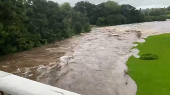
Flooding in Kerikeri from the Stone Bridge on Sunday. Photo / Ian Johnston
Motorist Tory Dixon told the Herald he saw flooding today while making the trip south from Peria, east of Kaitāia, to Auckland.
He said a slip in Fairburn was blocking the road towards SH1. “Then heading towards the Mangamukas, the flooding was extensively bad coming over the bridges, a lot of vehicles stopped,” he said.
He reported seeing houses flooded in Pāmapūria on SH1 and vehicles becoming submerged. “Once I got to south side of Mangamukas, the roads were clear [with] not much flooding” Dixon said.

The Kāeo webcam showed that at 9.30am the river's water level had neared the point where flooding may reach SH10. Photo / Northland Regional Council

Kāeo webcam water level reference board. Photo / Northland Regional Council
Northland’s rainfall for the 24 hours to 9.25am this morning was highest in these areas: Te Puhi at Mangakawakawa Trig (near Kaitāia ) 64.5mm; Touwai at Wētā (between Kerikeri and Mangōnui) 91.5mm; Kerikeri 97.5mm; Waitangi at McDonald Rd, 74mm; Ōtira (south of Kaikohe) 72mm; Whakapara at Puhipuhi (northeast of Hikurangi) 71.5mm; Ngunguru at Dugmores Rock, 79mm; Whangārei, 40.6mm;
Heavy rain deluges and thunderstorms are also predicted for Auckland today and tomorrow - the first day of the new school term.
It is the second weekend in a row tropically charged moist air has brought storm and flooding threats.
Between 6am and 6pm today there is the potential for localised downpours of 25 to 40mm per hour in Northland, which could occur with or without thunderstorms, MetService reported.

Wet weather in Tāmaki Makaurau / Auckland. Umbrellas in the central city. Photo / Alex Burton
MetService meteorologist Surprise Mhlongo said the system will hit Northland first and hardest.
Northland’s heavy rain and severe thunderstorm watch, which was originally set until 3pm, has now been extended to 6pm today.
Mhlongo said Aucklanders can expect wet weather and potential thunderstorms today and tomorrow.
Thunderstorms are also possible for Coromandel Peninsula, Bay of Plenty, and Gisborne.
“The weather system is very slow-moving so it’ll hang around between Auckland and Northland today with a definite possibility of thunderstorms tomorrow,” he said.
Civil Defence Northland has updated its online alerts, advising residents to take care while driving and look out for threatening weather.
“Rainfall of this intensity can cause surface and/or flash flooding, especially in low-lying areas ... and may also lead to slips,” it warned.
NZTA is also warning motorists to take care in the wet weather - to drive to the conditions, keep headlights on and maintain safe travel distances.
NZTA also advised that Mangamuka Gorge is closed due to a slip.

A downed tree has blocked Mangamuka Gorge from the southern side, a Far North resident said. Photo / Stacey Cowell
“There is a lot of uncertainty with respect to the amounts and distribution of significant heavy rain in Northland,” MetService warned, noting possibilities of flash and surface flooding, and challenging driving visibility in heavy rain.

Whangaruru North Residents and Ratepayers Association reports Punaruku has flooded. Photo / Supplied
The latest MetService thunderstorm risk suggests a moderate threat of thunderstorms in the Far North, north of Kaitāia to Bay of Islands, as well as heavy rain with intensities of 10-25mm/h.
There is a moderate risk of thunderstorms spreading south over Northland, reaching Dargaville to Whangārei around midnight. There is also a low risk of thunderstorms over Auckland and the northern Coromandel Peninsula.
MetService meteorologist Sarah Haddon said warm, moist air is being pulled across the country by a low-pressure system in the north Tasman Sea.
The MetService said there’s still a lot of uncertainty around the amounts and distribution of significant heavy rain in Northland.
“Downpours are possible. Amounts of rain are expected to approach warning criteria and possibly exceed them in localised areas, especially during thunderstorms and downpours,” the MetService said.
The top of the North Island was battered as former tropical Cyclone Tam slowly rolled over the country last week.
More than 20 Far North homes are still without power a week after it struck the region.
Take your Radio, Podcasts and Music with you