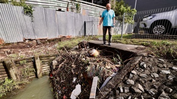
- Dozens of Aucklanders were hit by flooding inside their homes as authorities scrambled to respond to 175 callouts during ‘intense’ thunderstorms.
- Residents say the storm hit before any warning was issued, while the Metservice said thunderstorms are “notoriously difficult to forecast”.
- The rain was accompanied by thunder and lightning – with up to 750 strikes.
- A Civil Defence centre has been set up in Three Kings at the Fickling Convention Centre.
- Ex-tropical Cyclone Tam brings heavy rain and large waves to the North and upper South Islands today.
An Auckland councillor is demanding answers after official warnings arrived only an hour into the city’s damaging thunderstorms and flooding.
Residents were left with a “vacuum of information, no advice and no real guidance” on what was to come, Waitākere councillor Shane Henderson told Newstalk ZB.
“I want to know why warnings weren’t issued a bit earlier …these things are notoriously hard to predict, but I’d just say that we err on the side of caution, and maybe MetService needs to have a look at some of the trigger points, because it was certainly pretty gnarly well before the warnings came out.”
Dozens of Aucklanders were hit by flooding inside their homes as authorities scrambled to respond to 175 callouts during the wild weather with up to 110mm of rain falling overnight.
Henderson and many others had noted the similarity with the deadly and damaging Auckland Anniversary Weekend floods two years ago, where there were failings in how quickly and appropriately residents were warned of the coming danger.
“We’re afraid of that kind of situation repeating, and people need to be assured that we’ve got those systems in place so that we know what’s going on.”
Asked why there was no warning before the weather system arrived, MetService meteorologist Alec Holden earlier told NZME:
“That is a very good question.“
“In this case thunderstorms are historically and notoriously difficult to forecast. In this case the worst of it came from the fact that none of those individual thunderstorm cells were particularly notable, but it was the unfortunate incident of them coming one after another after another … to result in such high rainfall amounts.”
STORY CONTINUES AFTER LIVE BLOG
- 'Biblical storm': 750 lightning strikes hit Auckland
- 'No warning': Dozens of Auckland homes flood, 175 emergency callouts after deluge
STORY CONTINUES
Streets were swamped, cars were stranded, homes surrounded by water and power knocked out during the night.
A North Shore resident said it was the most severe storm she had experienced on the Shore by far.
“House shaking, no power, crying and scared 5-year-old and no warning at all.”
Another person said: “Insanely loud sound of the thunder and lightning over Bayview.”
Many Aucklanders are now asking about the apparent lack of warning and comparing the situation to the devastating Auckland Anniversary weekend floods.
Holden of MetService said an “arm of rain” that stretched out from the centre of Cyclone Tam was responsible for the intense downpours and thunderstorms.
 A home surrounded by floodwaters at the intersection of Potter and Parkinson Aves, Mt Roskill. Photo / Hayden Woodward
Areas between Mt Roskill and Albany appeared to have been worst hit, with some areas recording between 55mm to 110mm overnight rainfall.
 A man climbed out through his car window after becoming trapped by floodwaters on Onehunga Harbour Rd early this morning. Photo / Hayden Woodward
A Herald photographer said the worst-affected areas appeared to be around Mt Roskill and Sandringham, including Stoddard and O’Donnell Aves and Sandringham Rd.
“There was no warning at all. Residents are absolutely p***ed.”
Fire and Emergency NZ said they received more than 170 weather-related calls across Auckland at the peak of the storm.
A person staying at the Cordis in Auckland’s CBD said the thunder appeared to have set off the fire alarm and hundreds of people were in the the street.
Storm hangs on this Easter weekend
After severe rain and wind lashed the North Island, ex-tropical Cyclone Tam continues to hang on this Easter weekend, directing unstable fronts and troughs onto the northern South Island.
Meteorologists continue to keep an eye on a second weather system looming for New Zealand next week.
Ex-tropical Cyclone Tam currently lies west of New Zealand and will slowly weaken over the Easter weekend.
MetService meteorologist Samkelo Magwala said heavy falls are still on the cards for much of the country despite the weather overall “improving significantly”.
 After severe rain and wind lashed New Zealand, Cyclone Tam continues to hang on this Easter weekend, directing unstable fronts and troughs on to the northern South Island. Image / Windy.com
Tasman, Nelson and northern Marlborough should expect some heavy falls today, Magwala said.
Auckland will likely receive scattered rain that could turn heavy, with possible thunderstorms before midday also likely.
“Associated fronts move southwards over the country through into Saturday, bringing heavy rain to parts of the North Island and upper South Island.
“Large waves affecting eastern coastlines of the upper North Island are expected to gradually ease,” said MetService.
 Paeroa Towing Services rescues stranded cars from flooding overnight. Photo / Paeroa Towing Services
The system has also brought a wave of hot and humid air with potential for “record-breaking April temperatures” across the country.
Magwala told the Herald Wellington is in for an abnormal high of 25C today.
MetService said daytime highs today and Sunday may even reach the mid to high 20s elsewhere in the eastern and lower North Island.
Niwa meteorologist Seth Carrier told the Herald Tam’s remnants would slowly move away from New Zealand, and it might take until Tuesday or Wednesday for all the associated rainfall to end.
 Debris, strong winds and changeable weather on Auckland's North Shore at Cheltenham beach. Photo / Alex Burton
Heavy Rain Warning – Orange
A number of regions still remain under heavy rain warnings today, where the risk of streams and rivers rising also remains.
MetService says regions under these warnings could experience surface flooding, slips, and difficult driving conditions today.
- Gisborne/Tairāwhiti north of Tokomaru Bay, also Bay of Plenty northeast of Ōmaio – until 6am Saturday, April 19
- Mt Taranaki/Taranaki Mounga – until noon Sunday, April 20
- Tasman northwest of Motueka – until midnight Saturday, April 19
How likely is another storm next week?
The new weather system appeared to be tracking towards New Zealand from the northeast on Monday and Tuesday.
Magwala said that at this early stage, there is a “low potential” for another tropical cyclone to develop.
It is still too early to determine if it would amount to anything significant, Magwala said.
Take your Radio, Podcasts and Music with you