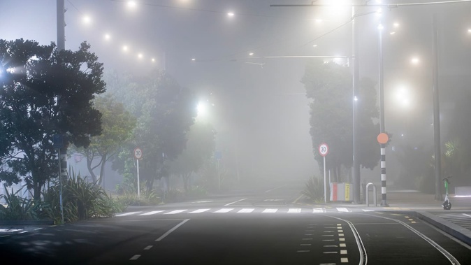
Flights are being delayed as Aucklanders wake to a thick blanket of fog covering the city.
The New Zealand Transport Agency is also warning motorists to take care as the fog affects visibility for commuters.
A spokesperson for Auckland Airport said fog restrictions were put in place at 1.10am this morning.
STORY CONTINUES AFTER LIVEBLOG
STORY CONTINUES
MetService meteorologist Surprise Mhlongo said the fog is not going anywhere anytime soon.
He said they expect the fog to linger into the early hours of the afternoon before only a brief respite.
“It will return in the early evening and last again until tomorrow morning.”
He said there are patches of heavy fog throughout the North Island, but none as bad as Auckland and Northland.
Fifteen regional flights have been delayed as well as five domestic main trunk flights.
Nine flights have been cancelled.
International flights have not been affected by the foggy conditions.
NZTA urged motorists to take extra care of the roads this morning due to “reduced visibility”.
“Remember to keep your lights on, allow extra time and mind your following distance.”
Last month, over 100 flights out of Auckland Airport were delayed or cancelled due to thick fog.
MetService forecaster Lewis Ferris said a mixing pot of bad ingredients was causing the fog to hang around.
He said the sun’s low angle due to the winter solstice, high clouds blocking the sun, and the lack of wind made for the perfect foggy conditions.
The weather also played havoc with the city’s transport system.
Rare polar phenomenon could mean stormy conditions
People across the upper North Island are being told to brace for severe weather, with gale-force winds, intense downpours, slips and flooding possible.
After a week of clear blue skies and record-breaking high pressure, a moisture-packed northeasterly flow is set to bring dramatically different weather to open the second half of the school holidays.
Yesterday, Auckland was hit by a band of electrical storms. Coromandel Peninsula, Bay of Plenty, and west of Rotorua were also square in the firing line, with MetService having issued orange-level heavy rain warnings for those regions.
It comes as meteorologists are closely watching signs of a rare phenomenon deep below New Zealand, which could ultimately influence stormy conditions here in the weeks ahead.
What’s called “sudden stratospheric warming” (SSW) occurs when the temperature of the stratosphere – that’s the layer of the atmosphere 30km to 50km above ground – over the South Pole climbs by more than 25C.
Right now, Niwa meteorologist Ben Noll said a “pattern of warming” was being observed in the stratosphere above East Antarctica – and it was possible it could reach the threshold of becoming a “minor” SSW event.
Such events were rare in the Southern Hemisphere, with only three – in 2002, 2010 and 2019 – recorded in the satellite era.
Take your Radio, Podcasts and Music with you


