- MetService has issued severe thunderstorm watch for the Central North Island for later this afternoon and evening
- Some of the thunderstorms could be slow-moving and create localised downpours of 25mm/h to 40mm/h
- Forecasters are also watching potential for a tropical cyclone to form east of Australia - but any threat to New Zealand is low
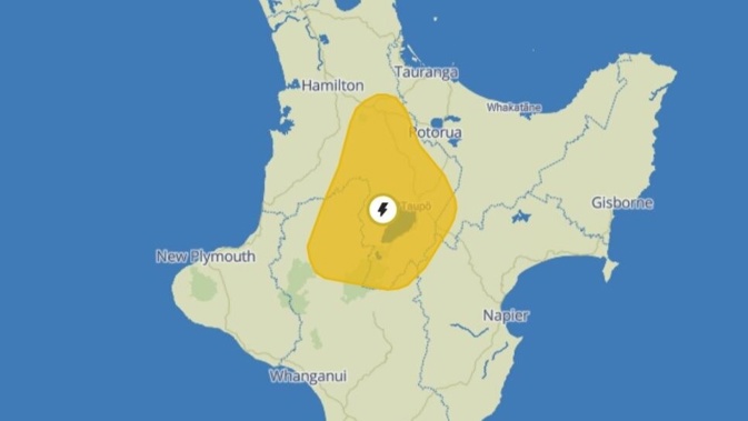
Forecasters are warning of potential for severe thunderstorms across the central North Island later today – bringing a risk of slips and flash flooding.
MetService has issued a severe thunderstorm “watch” from 3pm to 10pm this afternoon and evening, covering a large area from southern Waikato and eastern Waitomo to Taumarunui, Taupō and to the far southwest of Rotorua.
Some of those thunderstorms could also be slow-moving, severe and capable of localised downpours of 25mm/h to 40mm/h.
That meant the potential for surface and flash flooding – especially about low-lying areas like streams, rivers and narrow valleys – while making for hazardous driving conditions.
MetService meteorologist Clare O’Connor said thunderstorm risk came from a combination of light wind and summertime heating making for unstable air.
“They’re both going to allow those thunderstorms to form – but the risk is potentially localised heavy rain, as the light winds mean the thunderstorms won’t move too far from where they form.”
O’Connor said these storms could develop quickly – and forecasters were ready to issue local red warnings if they saw one form.
“We do have red warnings that come through as push notifications on our app – or otherwise, people can keep up to date by visiting our severe weather web page.”
Today’s weather action comes just days after heavy thunderstorms over the Central North Island saw a Taupō man thrown off his feet by a lightning strike.
Meanwhile, MetService is also closely watching a low pressure system in the Coral Sea, east of Australia, that may deepen today – but there’s still a low chance of it forming into a tropical cyclone.
The agency’s latest bulletin gave a “low” risk – or a 5% to 20% probability – of the system developing into a cyclone on Monday and Tuesday and a less than 5% risk thereafter.
O’Connor said that, if a cyclone did form, New Zealand would likely be buffered from dominant high pressure over the country.
Jamie Morton is a specialist in science and environmental reporting. He joined the Heraldin 2011 and writes about everything from conservation and climate change to natural hazards and new technology.
Take your Radio, Podcasts and Music with you


