No detour to cross the Ashburton River is expected to be established today.
Waka Kotahi NZ Transport Agency made the announcement at 11.45am on Tuesday.
It said there will be no detour in place throughout the day.
"There is no detour via road currently available to SH1 at Ashburton at this time.
"Waka Kotahi will be working closely with the Ashburton District Council to get an alternate route reopened, as soon as we can."
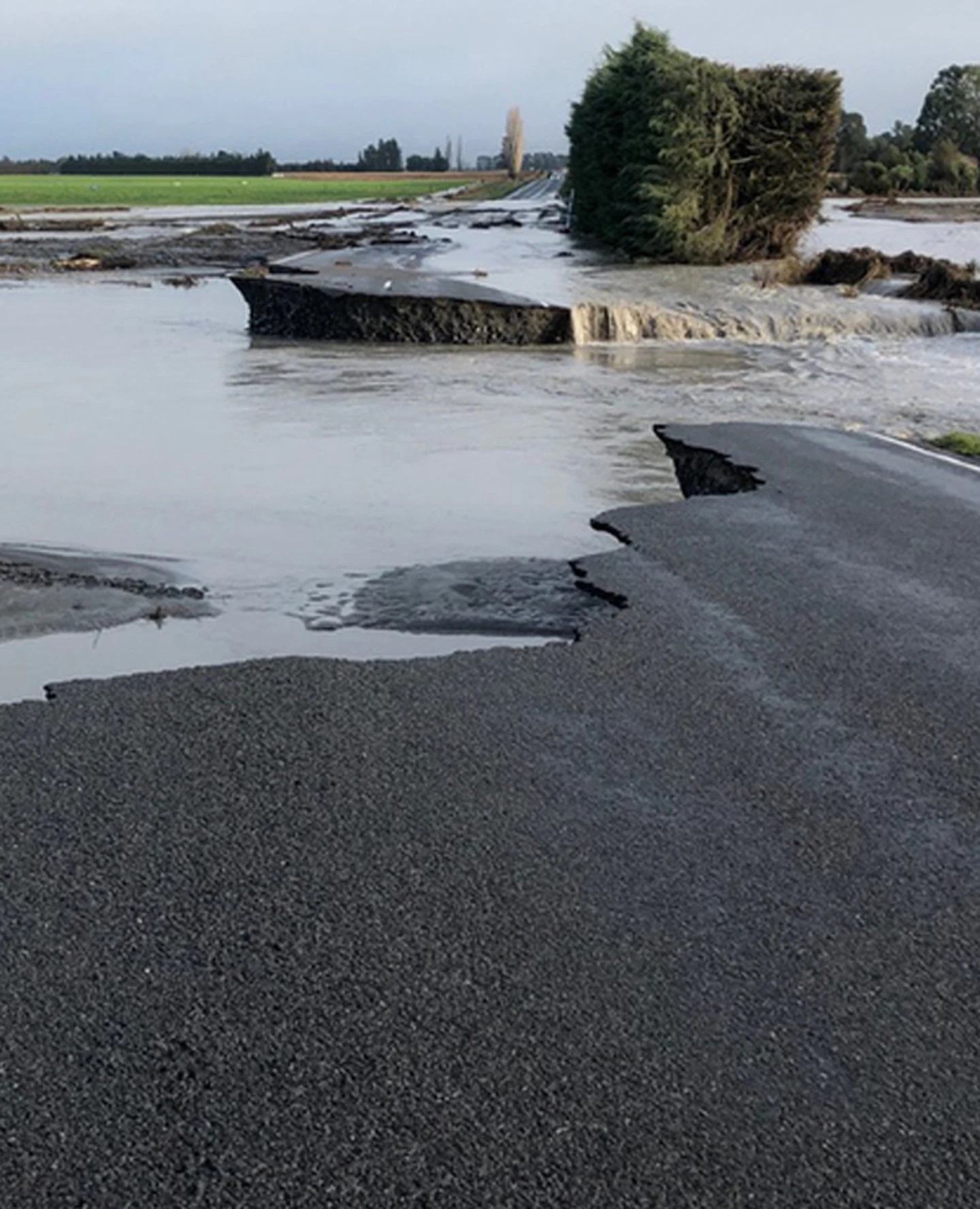
The Ashburton District Council alerted locals just before 7am that the Ashburton Bridge has been compromised due to bad weather.
Located on State Highway 1, it is the main bridge across the Ashburton River, and an issue with piles has caused the bridge to start slumping.

Ashburton River bridge looking upstream to the rail bridge on May 30. The bridge has been closed this morning due to slumping. (Photo / Linda Clarke, Ashburton Courier)
A council spokesman told the Herald that engineers have been on-site on Tuesday morning to assess the damage.
"They have found it is not going to be a band-aid-type fix, it is going to take several days."
He said the damage to the bridge was significant and they are working to establish alternative routes around it.
At 10.45am on Tuesday, the council released an update asking people not to queue at the bridge.
"Council is urgently working to establish an alternate route and it is anticipated that this route will open later today."
Motorists can still travel to Methven from Ashburton by using SH77, Winchmore Lauriston Rd, Dromore Methven Rd, Pole Rd, Cainbrae Rd and Line Rd.
A route across the Hinds River has been established through the Maronan Rd single-lane bridge. The Poplar Rd Bridge is also open.
Thompsons Track from SH77 to Mayfield Valetta Rd and from Jamiesons Rd to Winchmore Lauriston Rd is closed.

Waka Kotahi NZ Transport Agency said weather conditions in the Canterbury region had mostly eased. But rivers would remain swollen for some time.
Locals were reminded that floodwaters will take time to recede.
"A heavy rain warning remains in place for Canterbury about and north of Cheviot - and Marlborough about and south of Kaikōura."

Tinwald side of Ashburton bridge on State Highway One after it was closed. (Photo / Phil Hooper)
The latest information comes as two to three months of rain pelted Canterbury in the space of a few days in a deluge that has been labelled a one-in-100-year event.
Local authorities across Canterbury evacuated more than 300 properties amid wild weather that forced hundreds of residents to flee raging floodwaters threatening their homes.
Ten state highways were closed, while other roads were ruined and four bridges washed away.
Those displaced from their homes stayed with friends and whānau while others went to evacuation centres set up by Civil Defence and marae.
However, yesterday many of the evacuated residents were able to start returning to their homes, to begin the inevitable clean-up of the debris and damage left behind.
MetService meteorologist Angus Hines said yesterday the rain was easing across the region — but caution was still required around swollen rivers.
"The rivers of course will still be running high and they can stay high even after the local rainfall finished."
A rare "red warning" was issued by MetService late last week, just the second time such a warning had been put out by the authority.
The red warning between Geraldine and Amberley lifted at 7pm last night but an orange warning from Amberley to Kaikōura was due to lift at midnight.
Two to three months of rain pelted Canterbury in the space of a few days in a deluge that has been labelled a one-in-100-year event.
Local authorities across Canterbury evacuated more than 300 properties amid wild weather that forced hundreds of residents to flee raging floodwaters threatening their homes.
Ten state highways were closed, while other roads were ruined and four bridges washed away.

Selwyn Huts residents had to evacuate as the water threatened to cut off the settlement. (Photo / George Heard)
Those displaced from their homes stayed with friends and whānau while others went to evacuation centres set up by Civil Defence and marae.
However, yesterday many of the evacuated residents were able to start returning to their homes, to begin the inevitable clean-up of the debris and damage left behind.
MetService meteorologist Angus Hines said yesterday the rain was easing across the region — but caution was still required around swollen rivers.
"The rivers of course will still be running high and they can stay high even after the local rainfall finished."
A rare "red warning" was issued by MetService late last week, just the second time such a warning had been put out by the authority.
The red warning between Geraldine and Amberley lifted at 7pm last night but an orange warning from Amberley to Kaikōura was due to lift at midnight.

Hundreds of people have been forced to evacuate from the rising waters. (Photo / George Heard)
Scores of Waimakariri residents were told to leave their homes immediately on Sunday night as stopbanks on two flooded rivers were at risk of failing or expected to give way.
Evacuations of residents in low-lying areas of The Pines Beach continued yesterday afternoon with emergency services knocking on residents' doors.
Others were put on high alert and warned to be ready to evacuate should it be needed.
Farmers were urged to take extreme care and to put their own safety first as they worked in dangerous conditions to rescue animals and move stock, RNZ reported.
According to figures from Niwa, Lismore, near Ashburton, received 238mm of rain in 2.2 days — the same amount it experienced in the previous 187 days.
Aerial photos show the aftermath of the weather event where homes were left completely surrounded in brown water and paddocks submerged.
Residents in Canterbury woke yesterday to a region-wide state of emergency with many students staying home from school after their schools and preschools were closed.
Parts of Akaroa were submerged yesterday. Residents in the township were asked to conserve water, as the supply relied heavily on surrounding streams which were being impacted by the heavy rains.
That meant that drinking water could only be sourced from bores.
Meanwhile the rain also resulted in heavy wastewater overflows yesterday with residents warned to treat any wastewater they come into contact with as potentially contaminated.

Aerial view of flooding in Canterbury as days of heavy rain has brought widespread water level rises. (Photo / George Heard)
The Ashburton District Council confirmed on Monday its pond on Wilkins Rd had flooded.
Mayor Neil Brown said stormwater got into the pond and it overflowed, leaving floodwater contaminated with sewage. A pipe from the pond was also damaged due to the flooding, so contaminated water was getting into a creek heading towards Lake Hood.
Yesterday a car was spotted down a bank near the Waimakariri Gorge.
Fire trucks arrived at the scene with firefighters and a high ropes expert was deployed who determined that nobody was inside the vehicle.
Meanwhile, the Mackenzie District Council yesterday warned there could be livestock on the loose as river levels fall.
It said fencing may have been washed away, meaning stock may not be contained, and could wander onto roads.
It also warned debris and gravel in the rivers could cause further damage to bridges.
The MetService is forecasting drier conditions today, with showers expected to clear by the afternoon.
Take your Radio, Podcasts and Music with you


