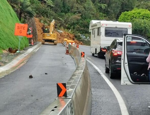
School holiday motorists can expect delays after heavy rain caused a slip that closed State Highway 1 north of Auckland at the Brynderwyn Hills.
“Due to a slip, SH1 at Brynderwyn Hills is closed in both directions,” the NZ Transport Agency said about the section of road about 100km north of the city centre.
“Please follow provided detours and allow additional time for travels through the area today. Contractors are on-site working to clear this slip.”

The main road isn’t the only one to fail under the ‘weather bomb’ that struck last night, with the main detour also taken out.
“We also have an underslip reported this morning on Paparoa-Oakleigh, meaning that route not suitable as detour at present,” Whangarei District Council said.
Cars and light vehicles will need to detour between Waipu and Kaiwaka along Nova Scotia Drive, Cove Rd, Garbolino Rd and Kaiwaka-Mangawhai Rd.
Trucks are asked to detour using SH14 and SH12.
Traffic had been passing through the Brynderwyn section of the highway about an hour ago after a smaller slip caused by overnight rain was cleared by road workers.
One motorist posted a video to social media showing the smaller slip, saying: “Just went through Brenderwyns (sic) it’s not holding up well with a bit of rain.”
However, the section of highway was later closed by authorities.
It comes after heavy rainfalls hit Auckland and Northland last night with showers and intermittent heavy bursts expected to continue in the regions today.
The Brynderwyn stretch of SH1 had only last month been reopened after earlier severe slip damage.
NZTA said at the time it had moved more than 200,000 cubic metres of soil following slips in April and earlier.
“SH1 is now more reliable for Northland,” the agency said.
The “huge” amount of earth cut away, along with the terraced levels and piles and retaining walls installed “will help the road withstand the next severe weather event”, it said.
Elsewhere, heavy falls are tipped to move onto threaten Gisborne and the East Coast today.
MetService has issued a heavy rain watch for the Gisborne region, which is active from 4am to 4pm today, prompting Uawa Civil Defence – Tologa Bay East Coast to warn residents to keep their safety and that of their families front of mind.
Waves up to 10 metres high were expected at the centre of the storm, the National Institute of Water and Atmospheric Research (Niwa) said. The worst of the weather was expected offshore as a low-pressure system developed into a “weather bomb”, scientifically termed an explosive cyclogenesis.
MetService also issued heavy rain watches for Northland, Auckland north of Whangaparāoa Peninsula and Great Barrier Island; the Coromandel Peninsula; and the Bay of Plenty. The last of these lapsed at 9am today.
Auckland’s Saturday was expected to begin with heavy falls continuing north of Whangaparāoa before they eased to showers in the afternoon. MetService expected these showers to clear in the evening. A daily high of 15C was forecasted and the overnight low was tipped to dip to 11C.
Sunday in the City of Sails had partly cloudy conditions forecast, with showers – some heavy – predicted to develop in the afternoon. The daily high was expected to reach 17C and the low was expected to remain at 11C.
Monday should be partly cloudy with some showers developing in the morning. It was expected to reach 16C and fall to 10C. Looking further ahead, rain was expected to clear on Tuesday, when cloudy skies were tipped to take over. Fine conditions were forecast from Wednesday.
Take your Radio, Podcasts and Music with you


